IMAGES TAKEN NEAR TO
Elm Road, KETTERING, NN15 5NF
Introduction
This page details the photographs taken nearby to Elm Road, NN15 5NF by members of the Geograph project.
The Geograph project started in 2005 with the aim of publishing, organising and preserving representative images for every square kilometre of Great Britain, Ireland and the Isle of Man.

There are currently over 7.5m images from over14,400 individuals and you can help contribute to the project by visiting https://www.geograph.org.uk
Image Map
Images are licensed for reuse under creativecommons.org/licenses/by-sa/2.0
Notes
- Clicking on the map will re-center to the selected point.
- The higher the marker number, the further away the image location is from the centre of the postcode.
Image Listing (8 Images Found)
Images are licensed for reuse under creativecommons.org/licenses/by-sa/2.0
Image
Details
Distance
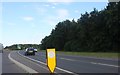
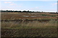
6
Roundabout on the A6, Burton Latimer
It currently doesn't have any exits off the road but is there in readiness for a new green field housing development.
Image: © David Howard
Taken: 29 Jul 2019
0.21 miles
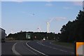
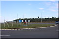
7
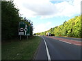
A6 towards Kettering approaching roundabout
Image: © JThomas
Taken: 23 Sep 2022
0.21 miles
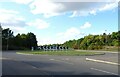
8
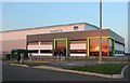
Bunzl Woodway on the A6, Burton Latimer
This was a green field site, I see most lost to houses, they are now being lost to any developments.
Image: © David Howard
Taken: 13 Sep 2020
0.25 miles