IMAGES TAKEN NEAR TO
The Drive, NORTHAMPTON, NN1 4SP
Introduction
This page details the photographs taken nearby to The Drive, NN1 4SP by members of the Geograph project.
The Geograph project started in 2005 with the aim of publishing, organising and preserving representative images for every square kilometre of Great Britain, Ireland and the Isle of Man.

There are currently over 7.5m images from over14,400 individuals and you can help contribute to the project by visiting https://www.geograph.org.uk
Image Map
Images are licensed for reuse under creativecommons.org/licenses/by-sa/2.0
Notes
- Clicking on the map will re-center to the selected point.
- The higher the marker number, the further away the image location is from the centre of the postcode.
Image Listing (42 Images Found)
Images are licensed for reuse under creativecommons.org/licenses/by-sa/2.0
Image
Details
Distance
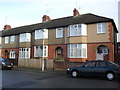
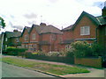
1
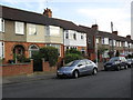
The Drive
Edwardian terraced houses in Abington.
Image: © Burgess Von Thunen
Taken: 3 Sep 2012
0.02 miles
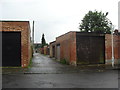
2
Abington
Alleyway between Highfield Road and Park Avenue North.
Image: © Burgess Von Thunen
Taken: 4 Dec 2012
0.05 miles
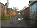
3
Abington
Alleyway between Kettering Road and The Drive.
Image: © Burgess Von Thunen
Taken: 20 Jul 2012
0.06 miles
4
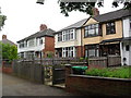
Kettering Road
1920s houses in Abington.
Image: © Burgess Von Thunen
Taken: 16 Jul 2012
0.07 miles
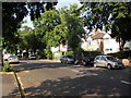
5
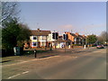
Park Avenue North
Showing a pelican crossing at the junction with The Drive.
Image: © Burgess Von Thunen
Taken: 4 Mar 2011
0.08 miles
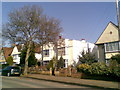
6
Brookland Road
1930s houses in Abington.
Image: © Burgess Von Thunen
Taken: 4 Dec 2012
0.08 miles
7
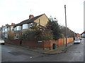
Abington
Corner of Brookland Road and Highfield Road.
Image: © Burgess Von Thunen
Taken: 4 Dec 2012
0.08 miles
8
Park Avenue North
1930s semis in Abington.
Image: © Burgess Von Thunen
Taken: 4 Mar 2011
0.10 miles
9
Lindsay Avenue
1930s council houses in Abington.
Image: © Burgess Von Thunen
Taken: 7 Jul 2011
0.13 miles
10
Kettering Road
1930s semis and bus stop in Abington.
Image: © Burgess Von Thunen
Taken: 27 Jul 2012
0.13 miles