IMAGES TAKEN NEAR TO
Clarke Road, NORTHAMPTON, NN1 4PL
Introduction
This page details the photographs taken nearby to Clarke Road, NN1 4PL by members of the Geograph project.
The Geograph project started in 2005 with the aim of publishing, organising and preserving representative images for every square kilometre of Great Britain, Ireland and the Isle of Man.

There are currently over 7.5m images from over14,400 individuals and you can help contribute to the project by visiting https://www.geograph.org.uk
Image Map
Images are licensed for reuse under creativecommons.org/licenses/by-sa/2.0
Notes
- Clicking on the map will re-center to the selected point.
- The higher the marker number, the further away the image location is from the centre of the postcode.
Image Listing (108 Images Found)
Images are licensed for reuse under creativecommons.org/licenses/by-sa/2.0
Image
Details
Distance
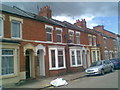
1
Clarke Road
Victorian terraces in Abington.
Image: © Burgess Von Thunen
Taken: 22 Sep 2015
0.01 miles
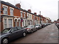
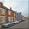
2
Clarke Road
Victorian bay-fronted terraces in Abington.
Image: © Burgess Von Thunen
Taken: 11 May 2010
0.03 miles
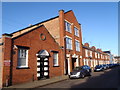
3
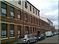
Clarke Road
Murray House; Victorian warehouse converted into apartments.
Image: © Burgess Von Thunen
Taken: 10 May 2010
0.03 miles
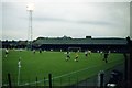
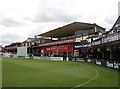
4
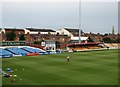
The County Ground before the start of play
A view of the western side of the ground, with one of the floodlight pylons towering above the small stand. The former press box, known as The Signal Box, is in the centre and the Northamptonshire players' practice kit on the grass on the left.
Image: © John Sutton
Taken: 21 Aug 2012
0.04 miles
5
Roe Road
Converted factories in Abington. Apparently the big one used to be a sweet factory.
Image: © Burgess Von Thunen
Taken: 12 Nov 2015
0.04 miles
6
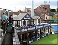
During the tea interval
The south-western corner of The County Ground at tea on the first day of a County Championship match between Northamptonshire and Derbyshire. The Aspers Casino is where the players (and some spectators) have lunch.
Image: © John Sutton
Taken: 21 Aug 2012
0.05 miles
7
Northampton: Pavilion Court, Roe Road
New flats have been built among the terraced houses of Roe Road. Their name acknowledges that the Northamptonshire County Cricket Ground, Wantage Road, is nearby.
Image: © John Sutton
Taken: 21 Sep 2017
0.05 miles
8
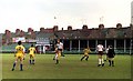
Northampton Town FC playing at the County Ground
Image: © Steve Daniels
Taken: 1 May 1981
0.06 miles
9
The Pavilion End
A lunchtime view of the Wantage Road end of the Northamptonshire County Cricket Ground. The Members' Pavilion is to the left and the Ken Turner Stand in the centre, from which there is a good view from behind the bowler's arm.
Image: © John Sutton
Taken: 21 Aug 2012
0.07 miles