IMAGES TAKEN NEAR TO
Kettering Road, KETTERING, NN14 6JP
Introduction
This page details the photographs taken nearby to Kettering Road, NN14 6JP by members of the Geograph project.
The Geograph project started in 2005 with the aim of publishing, organising and preserving representative images for every square kilometre of Great Britain, Ireland and the Isle of Man.

There are currently over 7.5m images from over14,400 individuals and you can help contribute to the project by visiting https://www.geograph.org.uk
Image Map (Loading...)


Getting Data...Please wait
Leaflet Map data © OpenStreetMap
Images are licensed for reuse under creativecommons.org/licenses/by-sa/2.0
Notes
- Clicking on the map will re-center to the selected point.
- The higher the marker number, the further away the image location is from the centre of the postcode.
Image Listing (88 Images Found)
Images are licensed for reuse under creativecommons.org/licenses/by-sa/2.0
Image
Details
Distance
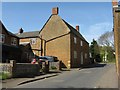
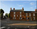
1
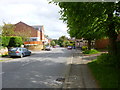
Rothwell, Kettering Road
B669, formerly A6.
Image: © Mike Faherty
Taken: 10 May 2014
0.02 miles
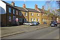
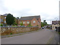
3
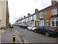
Rothwell, terraced housing
On Gordon Street.
Image: © Mike Faherty
Taken: 10 May 2014
0.07 miles
5
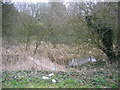
Mediaeval Fish Pond, Rothwell
The ponds were for keeping fish to feed the monks. There were once four ponds in this public park, two were filled in by a vandalising council in the sixties, the others saved, but it seems uncared for by the people of Rothwell - although not forgotten, judging by the rubbish. Is this Northamptonshire's most uncared for park?
Image: © Peter Watkins
Taken: 16 Mar 2006
0.07 miles
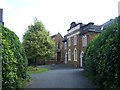
6
Rothwell, former UR Church
With churchyard, on Evison Road.
Image: © Mike Faherty
Taken: 10 May 2014
0.07 miles
7
Newham Farm, Wales Street
Image: © M J Richardson
Taken: 27 Apr 2010
0.09 miles
8
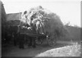
Harvest gathered in - 1953
The horses were 'Metal' and 'Nellie'. The farm yard has gone, and is now houses Image
Image: © M J Richardson
Taken: Unknown
0.09 miles
9
The Rowell Charter Inn, Rothwell
Parts date to the sixteenth century though most of what is visible in this picture is later than that https://historicengland.org.uk/listing/the-list/list-entry/1288713
Image: © Jonathan Thacker
Taken: 28 Sep 2020
0.09 miles
10
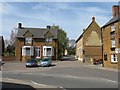
Wales Street
From the junction of Sun Hill and High Street. Newham Farm was at the top of the road.
Image: © M J Richardson
Taken: 27 Apr 2010
0.09 miles