IMAGES TAKEN NEAR TO
Stanley Street, KETTERING, NN14 6EA
Introduction
This page details the photographs taken nearby to Stanley Street, NN14 6EA by members of the Geograph project.
The Geograph project started in 2005 with the aim of publishing, organising and preserving representative images for every square kilometre of Great Britain, Ireland and the Isle of Man.

There are currently over 7.5m images from over14,400 individuals and you can help contribute to the project by visiting https://www.geograph.org.uk
Image Map (Loading...)


Getting Data...Please wait
Leaflet Map data © OpenStreetMap
Images are licensed for reuse under creativecommons.org/licenses/by-sa/2.0
Notes
- Clicking on the map will re-center to the selected point.
- The higher the marker number, the further away the image location is from the centre of the postcode.
Image Listing (17 Images Found)
Images are licensed for reuse under creativecommons.org/licenses/by-sa/2.0
Image
Details
Distance
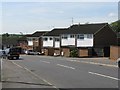
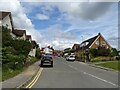
2
Houses on Glendon Road
At its junction with Ragsdale Street.
Image: © M J Richardson
Taken: 27 Apr 2010
0.07 miles
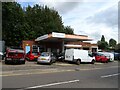
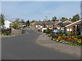
4
Columbus Crescent
Off the Glendon Road, and leading into the 'explorers' estate' - a development with streets named after maritime explorers. The valley of the Slade Brook is at the bottom of the hill.
Image: © M J Richardson
Taken: 27 Apr 2010
0.12 miles
5
Balfour Drive, Rothwell
Residential properties on this quiet road.
Image: © Peter Mackenzie
Taken: 26 Jun 2018
0.13 miles
6
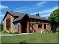
St Bernadette Roman Catholic Church, Rothwell
Image: © Geoff Pick
Taken: 30 Jul 2011
0.14 miles
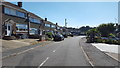
9
Columbus Crescent
Looking north towards Glendon Road, with Davis Close on the left.
Image: © M J Richardson
Taken: 27 Apr 2010
0.16 miles