IMAGES TAKEN NEAR TO
Cross Street, KETTERING, NN14 6DD
Introduction
This page details the photographs taken nearby to Cross Street, NN14 6DD by members of the Geograph project.
The Geograph project started in 2005 with the aim of publishing, organising and preserving representative images for every square kilometre of Great Britain, Ireland and the Isle of Man.

There are currently over 7.5m images from over14,400 individuals and you can help contribute to the project by visiting https://www.geograph.org.uk
Image Map
Images are licensed for reuse under creativecommons.org/licenses/by-sa/2.0
Notes
- Clicking on the map will re-center to the selected point.
- The higher the marker number, the further away the image location is from the centre of the postcode.
Image Listing (26 Images Found)
Images are licensed for reuse under creativecommons.org/licenses/by-sa/2.0
Image
Details
Distance
3
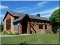
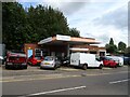
St Bernadette Roman Catholic Church, Rothwell
Image: © Geoff Pick
Taken: 30 Jul 2011
0.08 miles
8
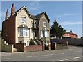
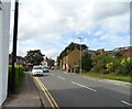
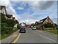
Houses on Glendon Road
At its junction with Ragsdale Street.
Image: © M J Richardson
Taken: 27 Apr 2010
0.12 miles
9
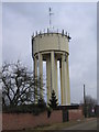
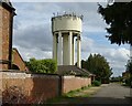
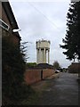
Water Tower Rothwell
The most prominent site for some miles around, probably only still standing as a useful income generator for Anglian Water - a mobile phone mast.
Image: © Peter Watkins
Taken: 16 Mar 2006
0.13 miles