IMAGES TAKEN NEAR TO
Moorfield Road, KETTERING, NN14 6AT
Introduction
This page details the photographs taken nearby to Moorfield Road, NN14 6AT by members of the Geograph project.
The Geograph project started in 2005 with the aim of publishing, organising and preserving representative images for every square kilometre of Great Britain, Ireland and the Isle of Man.

There are currently over 7.5m images from over14,400 individuals and you can help contribute to the project by visiting https://www.geograph.org.uk
Image Map (7 Images)


Getting Data...Please wait
Leaflet Map data © OpenStreetMap
Images are licensed for reuse under creativecommons.org/licenses/by-sa/2.0
Notes
- Clicking on the map will re-center to the selected point.
- The higher the marker number, the further away the image location is from the centre of the postcode.
Image Listing (7 Images Found)
Images are licensed for reuse under creativecommons.org/licenses/by-sa/2.0
Image
Details
Distance
2
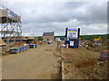
Rothwell, Harrington Park
Building site on Harrington Road.
Image: © Mike Faherty
Taken: 10 May 2014
0.19 miles
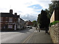
3
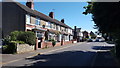
Houses in Rothwell
Terraced housing in Rothwell.
Image: © Peter Mackenzie
Taken: 26 Jun 2018
0.20 miles
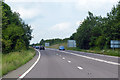
4
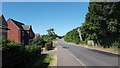
Leaving Rothwell
The B576 leaving Rothwell heading west.
Image: © Peter Mackenzie
Taken: 26 Jun 2018
0.21 miles
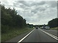
7
A6 towards Market Harborough
Just north of the interchange with the A14.
Image: © Robin Webster
Taken: 23 Jun 2019
0.23 miles