IMAGES TAKEN NEAR TO
Miller Close, KETTERING, NN14 4XF
Introduction
This page details the photographs taken nearby to Miller Close, NN14 4XF by members of the Geograph project.
The Geograph project started in 2005 with the aim of publishing, organising and preserving representative images for every square kilometre of Great Britain, Ireland and the Isle of Man.

There are currently over 7.5m images from over14,400 individuals and you can help contribute to the project by visiting https://www.geograph.org.uk
Image Map (Loading...)


Getting Data...Please wait
Leaflet Map data © OpenStreetMap
Images are licensed for reuse under creativecommons.org/licenses/by-sa/2.0
Notes
- Clicking on the map will re-center to the selected point.
- The higher the marker number, the further away the image location is from the centre of the postcode.
Image Listing (12 Images Found)
Images are licensed for reuse under creativecommons.org/licenses/by-sa/2.0
Image
Details
Distance
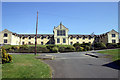
2
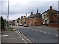
Huntingdon Road, Thrapston
Looking west. The road used to be the A604 but is superseded by the A14.
Image: © Will Lovell
Taken: 29 Mar 2006
0.20 miles
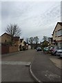
3
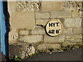
Bench Mark and Hydrant
The OS Bench Mark and Hydrant disc on the side of a house on Huntingdon road.
Image: © Michael Trolove
Taken: 21 Feb 2009
0.21 miles
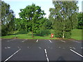
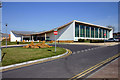
7
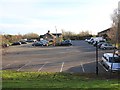
Thrapston Services
The services on junction 13 of the A14.
Image: © David P Howard
Taken: 2 Dec 2011
0.22 miles
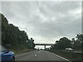
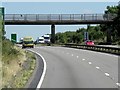
8
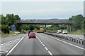
Footbridge over Westbound A14 near Thrapston
Image: © David Dixon
Taken: 5 Aug 2013
0.23 miles