IMAGES TAKEN NEAR TO
Roman Way, KETTERING, NN14 4TE
Introduction
This page details the photographs taken nearby to Roman Way, NN14 4TE by members of the Geograph project.
The Geograph project started in 2005 with the aim of publishing, organising and preserving representative images for every square kilometre of Great Britain, Ireland and the Isle of Man.

There are currently over 7.5m images from over14,400 individuals and you can help contribute to the project by visiting https://www.geograph.org.uk
Image Map
Images are licensed for reuse under creativecommons.org/licenses/by-sa/2.0
Notes
- Clicking on the map will re-center to the selected point.
- The higher the marker number, the further away the image location is from the centre of the postcode.
Image Listing (12 Images Found)
Images are licensed for reuse under creativecommons.org/licenses/by-sa/2.0
Image
Details
Distance
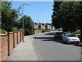
2
Thrapston - Houses Off Springfield Avenue
Image: © Peter Whatley
Taken: 2 Jun 2009
0.11 miles
5
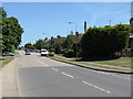
Thrapston - Oundle Road
Looking east from opposite the junction with John Street.
Image: © Peter Whatley
Taken: 2 Jun 2009
0.17 miles
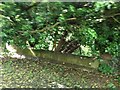
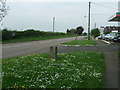
6
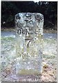
Old Milestone by Oundle Road, Thrapston
Carved stone post by the UC road (was A605), in parish of THRAPSTON (EAST NORTHAMPTONSHIRE District), Oundle Road, by garage and electricity sub-station, Northeast of cemetery, on the verge, on Southeast side of road. Erected by the Peterborough & Wellingborough turnpike trust in the 19th century.
Inscription reads:-
: 5 / FURLONGS / TO / THRAPSTON / CATTLE / MARKET : : TO / OUNDLE / 7 / MILES :
Grade II listed.
List Entry Number: 1226982 https://historicengland.org.uk/listing/the-list/list-entry/1226982
Milestone Society National ID: NR_ODTH07.
Image: © J Ward
Taken: 1 May 2005
0.20 miles
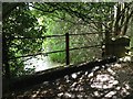
7
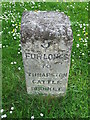
5 Furlongs To Thrapston Cattle Market
Old milestone at Thrapston, Northamptonshire for overall view see http://www.geograph.org.uk/photo/2999155
Image: © Keith Evans
Taken: 21 May 2012
0.20 miles
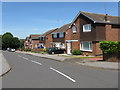
8
Thrapston - Mallard Close
Not a wader in sight.
Image: © Peter Whatley
Taken: 2 Jun 2009
0.20 miles
9
Old Milestone
Old milestone at Thrapston, Northamptonshire for close up view see http://www.geograph.org.uk/photo/2999142
Image: © Keith Evans
Taken: 21 May 2012
0.20 miles
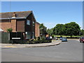
10
Thrapston - Springfield Avenue At Mallard Close
Image: © Peter Whatley
Taken: 2 Jun 2009
0.23 miles