IMAGES TAKEN NEAR TO
NN14 4RR
Introduction
This page details the photographs taken nearby to NN14 4RR by members of the Geograph project.
The Geograph project started in 2005 with the aim of publishing, organising and preserving representative images for every square kilometre of Great Britain, Ireland and the Isle of Man.

There are currently over 7.5m images from over14,400 individuals and you can help contribute to the project by visiting https://www.geograph.org.uk
Image Map (Loading...)


Getting Data...Please wait
Leaflet Map data © OpenStreetMap
Images are licensed for reuse under creativecommons.org/licenses/by-sa/2.0
Notes
- Clicking on the map will re-center to the selected point.
- The higher the marker number, the further away the image location is from the centre of the postcode.
Image Listing (9 Images Found)
Images are licensed for reuse under creativecommons.org/licenses/by-sa/2.0
Image
Details
Distance
1
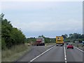
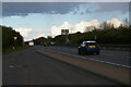
Eastbound A14 from a layby at Cranford St John
Eastbound traffic hurtles out of the late afternoon sun.
Image: © Christopher Hilton
Taken: 2 Apr 2022
0.04 miles
2

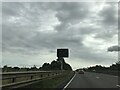
A605 closed ahead
Advance warning of a complete closure of the main route to Peterborough due to resurfacing work. On other signs, traffic was advised to use the A14/A1(M) via Huntingdon.
Image: © Peter Whatley
Taken: 27 Jul 2013
0.04 miles
3
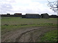
Barn and A14
These unusual wooden farm buildings sit close to the busy A14.
Image: © Michael Patterson
Taken: 30 Mar 2006
0.07 miles

7
Layby on the eastbound A14, Cranford St John
Image: © Christopher Hilton
Taken: 2 Apr 2022
0.14 miles
9
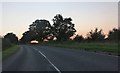
Cranford Road, Cranford St John
There are open fields behind the treeline.
Image: © David Howard
Taken: 13 Sep 2020
0.22 miles