IMAGES TAKEN NEAR TO
Faraday Court, KETTERING, NN14 4NB
Introduction
This page details the photographs taken nearby to Faraday Court, NN14 4NB by members of the Geograph project.
The Geograph project started in 2005 with the aim of publishing, organising and preserving representative images for every square kilometre of Great Britain, Ireland and the Isle of Man.

There are currently over 7.5m images from over14,400 individuals and you can help contribute to the project by visiting https://www.geograph.org.uk
Image Map (Loading...)


Getting Data...Please wait
Leaflet Map data © OpenStreetMap
Images are licensed for reuse under creativecommons.org/licenses/by-sa/2.0
Notes
- Clicking on the map will re-center to the selected point.
- The higher the marker number, the further away the image location is from the centre of the postcode.
Image Listing (13 Images Found)
Images are licensed for reuse under creativecommons.org/licenses/by-sa/2.0
Image
Details
Distance
1
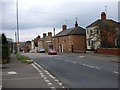
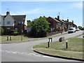
Huntingdon Road, Thrapston
Looking west. The road used to be the A604 but is superseded by the A14.
Image: © Will Lovell
Taken: 29 Mar 2006
0.04 miles
2
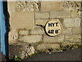
Bench Mark and Hydrant
The OS Bench Mark and Hydrant disc on the side of a house on Huntingdon road.
Image: © Michael Trolove
Taken: 21 Feb 2009
0.09 miles
4
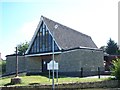
St Paul The Apostle Roman Catholic Church, Thrapston
Image: © Geoff Pick
Taken: 2 Aug 2011
0.17 miles
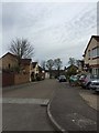
5
Thrapston - John Street
Photographed from across Oundle Road.
Image: © Peter Whatley
Taken: 2 Jun 2009
0.18 miles
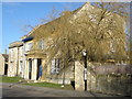
6
Thrapston House
Dates from about 1805, extended 1842 https://historicengland.org.uk/listing/the-list/list-entry/1226910 Now offices.
Image: © Jonathan Thacker
Taken: 28 Jun 2020
0.20 miles
7
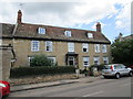
Belmount, Thrapston
Eighteenth century house https://historicengland.org.uk/listing/the-list/list-entry/1226909
Image: © Jonathan Thacker
Taken: 28 Jun 2020
0.22 miles
8
Thrapston House
Large house on the Huntingdon Road. It has been used as an office space for many businesses over the years.
Image: © Michael Trolove
Taken: 21 Feb 2009
0.22 miles
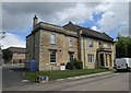
9
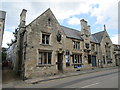
The Court House, Thrapston
A public house occupying the former Police Station built in 1870.
Image: © Jonathan Thacker
Taken: 28 Jun 2020
0.22 miles
10
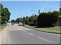
Thrapston - Oundle Road
Looking east from opposite the junction with John Street.
Image: © Peter Whatley
Taken: 2 Jun 2009
0.23 miles