IMAGES TAKEN NEAR TO
Cedar Drive, KETTERING, NN14 4JY
Introduction
This page details the photographs taken nearby to Cedar Drive, NN14 4JY by members of the Geograph project.
The Geograph project started in 2005 with the aim of publishing, organising and preserving representative images for every square kilometre of Great Britain, Ireland and the Isle of Man.

There are currently over 7.5m images from over14,400 individuals and you can help contribute to the project by visiting https://www.geograph.org.uk
Image Map
Images are licensed for reuse under creativecommons.org/licenses/by-sa/2.0
Notes
- Clicking on the map will re-center to the selected point.
- The higher the marker number, the further away the image location is from the centre of the postcode.
Image Listing (14 Images Found)
Images are licensed for reuse under creativecommons.org/licenses/by-sa/2.0
Image
Details
Distance
3
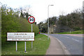
Thrapston border in Midland Road
Centre picture can be seen the remains of a bridge which carried a railway line.
Image: © Richard Dear
Taken: 21 Mar 2007
0.11 miles
4

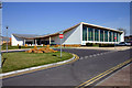
Gable end, Foundry Walk
Modern houses now sit where the former engineering works of Smith & Grace stood. The stone frieze from the works has been recycled and incorporated into the gable end of this house. The http://www.picturesofengland.com/England/Northamptonshire/Thrapston/pictures/1130182 shows part of the engineering works after a fire.
A visit to the works was often required at harvest time to purchase belts for grain elevators that all ways seemed to block up and then burn the belts out when you nipped away for a coffee.
Image: © Michael Trolove
Taken: 13 Jul 2012
0.11 miles
5
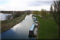
Boats on River Nene at Thrapston
The River Nene has been canalised at this point.Picture was taken from the disused railway line.
Image: © Richard Dear
Taken: 21 Mar 2007
0.11 miles
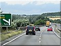
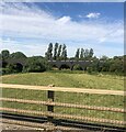
7
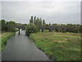
Crossing the River Nene near Thrapston from A14
The viaduct at the back carried a now disused railway
Image: © John Firth
Taken: 13 Sep 2010
0.13 miles
9
Railway viaduct crossing the River Nene
This once carried the Kettering to Huntingdon railway line but no longer in use.
Image: © Eirian Evans
Taken: 24 Jul 2022
0.17 miles