IMAGES TAKEN NEAR TO
Newtown Street, KETTERING, NN14 4HW
Introduction
This page details the photographs taken nearby to Newtown Street, NN14 4HW by members of the Geograph project.
The Geograph project started in 2005 with the aim of publishing, organising and preserving representative images for every square kilometre of Great Britain, Ireland and the Isle of Man.

There are currently over 7.5m images from over14,400 individuals and you can help contribute to the project by visiting https://www.geograph.org.uk
Image Map
Images are licensed for reuse under creativecommons.org/licenses/by-sa/2.0
Notes
- Clicking on the map will re-center to the selected point.
- The higher the marker number, the further away the image location is from the centre of the postcode.
Image Listing (11 Images Found)
Images are licensed for reuse under creativecommons.org/licenses/by-sa/2.0
Image
Details
Distance
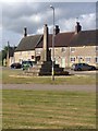
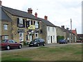
3
Woodford, a view from the allotment gardens
Image: © Michael Trolove
Taken: 16 Jan 2013
0.03 miles
4
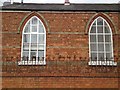
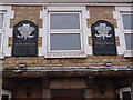
Empty pub and Fish & Chip shop in Woodford
Note the "Licensed to Brew" sign on the upper middle window cill.
Image: © Michael Trolove
Taken: 16 Jan 2013
0.03 miles
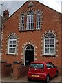
5
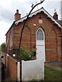
Licensed to Brew
Signage on the closed Prince of Wales pub in Woodford Image
Image: © Michael Trolove
Taken: 16 Jan 2013
0.03 miles
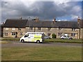
10
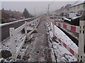
Utility works on Mill Road
Morrison Utilities digging a trench for a gas main supply in Woodford.
Image: © Michael Trolove
Taken: 16 Jan 2013
0.21 miles