IMAGES TAKEN NEAR TO
De Capel Close, KETTERING, NN14 4HR
Introduction
This page details the photographs taken nearby to De Capel Close, NN14 4HR by members of the Geograph project.
The Geograph project started in 2005 with the aim of publishing, organising and preserving representative images for every square kilometre of Great Britain, Ireland and the Isle of Man.

There are currently over 7.5m images from over14,400 individuals and you can help contribute to the project by visiting https://www.geograph.org.uk
Image Map (Loading...)


Getting Data...Please wait
Leaflet Map data © OpenStreetMap
Images are licensed for reuse under creativecommons.org/licenses/by-sa/2.0
Notes
- Clicking on the map will re-center to the selected point.
- The higher the marker number, the further away the image location is from the centre of the postcode.
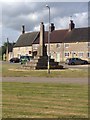
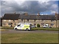
Image Listing (14 Images Found)
Images are licensed for reuse under creativecommons.org/licenses/by-sa/2.0
Image
Details
Distance
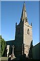
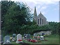
3
St Mary's Church Woodford
Seen from a riverside meadow.
Image: © Will Lovell
Taken: 1 Mar 2006
0.11 miles
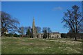
7
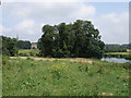
Riverside view looking towards Woodford
The type of view on offer for walkers on the Nene Way long distance foot path.
Image: © Michael Trolove
Taken: 28 Jun 2009
0.18 miles
8
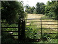
Follow the arrow, Nene Way, Woodford
Image: © Michael Trolove
Taken: 28 Jun 2009
0.19 miles
9
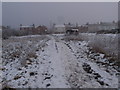
Woodford, a view from the allotment gardens
Image: © Michael Trolove
Taken: 16 Jan 2013
0.22 miles