IMAGES TAKEN NEAR TO
Denford Ash, KETTERING, NN14 4EW
Introduction
This page details the photographs taken nearby to NN14 4EW by members of the Geograph project.
The Geograph project started in 2005 with the aim of publishing, organising and preserving representative images for every square kilometre of Great Britain, Ireland and the Isle of Man.

There are currently over 7.5m images from over14,400 individuals and you can help contribute to the project by visiting https://www.geograph.org.uk
Image Map
Images are licensed for reuse under creativecommons.org/licenses/by-sa/2.0
Notes
- Clicking on the map will re-center to the selected point.
- The higher the marker number, the further away the image location is from the centre of the postcode.
Image Listing (7 Images Found)
Images are licensed for reuse under creativecommons.org/licenses/by-sa/2.0
Image
Details
Distance
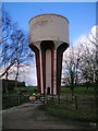
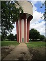
4
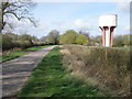
Water Tower near Briggs Lodge Farm
A quiet rural scene on the minor road between Denford and Raunds
Image: © Michael Trolove
Taken: 3 Apr 2011
0.06 miles
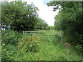
5
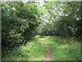
Bridleway alongside Vicarage Spinney
Vicarage Spinney is on the left.
Image: © Jonathan Thacker
Taken: 28 Jun 2020
0.17 miles
6
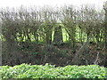
Triangulation Pillar near Denford Ash
Hidden in the hedgerow, a triangulation pillar near the village of Denford.
Image: © Michael Trolove
Taken: 3 Apr 2011
0.20 miles
7
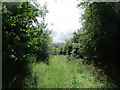
Bridleway near Vicarage Spinney
Vicarage Spinney visible in the distance.
Image: © Jonathan Thacker
Taken: 28 Jun 2020
0.22 miles