IMAGES TAKEN NEAR TO
Denford, KETTERING, NN14 4EN
Introduction
This page details the photographs taken nearby to NN14 4EN by members of the Geograph project.
The Geograph project started in 2005 with the aim of publishing, organising and preserving representative images for every square kilometre of Great Britain, Ireland and the Isle of Man.

There are currently over 7.5m images from over14,400 individuals and you can help contribute to the project by visiting https://www.geograph.org.uk
Image Map (Loading...)


Getting Data...Please wait
Leaflet Map data © OpenStreetMap
Images are licensed for reuse under creativecommons.org/licenses/by-sa/2.0
Notes
- Clicking on the map will re-center to the selected point.
- The higher the marker number, the further away the image location is from the centre of the postcode.
Image Listing (6 Images Found)
Images are licensed for reuse under creativecommons.org/licenses/by-sa/2.0
Image
Details
Distance
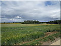
1
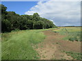
Field edge and plantation near Denford Ash Farm
Image: © Jonathan Thacker
Taken: 28 Jun 2020
0.17 miles
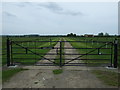
5

Roadway gate near Denford Ash Farm
There is a gap for pedestrians on the left.
Image: © Jonathan Thacker
Taken: 28 Jun 2020
0.23 miles
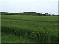
6
Barleyfield and Denford Ash
Denford Old Ash on the right.
Image: © Jonathan Thacker
Taken: 28 Jun 2020
0.23 miles