IMAGES TAKEN NEAR TO
Chapel Street, KETTERING, NN14 4DL
Introduction
This page details the photographs taken nearby to Chapel Street, NN14 4DL by members of the Geograph project.
The Geograph project started in 2005 with the aim of publishing, organising and preserving representative images for every square kilometre of Great Britain, Ireland and the Isle of Man.

There are currently over 7.5m images from over14,400 individuals and you can help contribute to the project by visiting https://www.geograph.org.uk
Image Map (Loading...)


Getting Data...Please wait
Leaflet Map data © OpenStreetMap
Images are licensed for reuse under creativecommons.org/licenses/by-sa/2.0
Notes
- Clicking on the map will re-center to the selected point.
- The higher the marker number, the further away the image location is from the centre of the postcode.
Image Listing (8 Images Found)
Images are licensed for reuse under creativecommons.org/licenses/by-sa/2.0
Image
Details
Distance
1
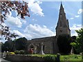
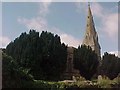
Church of the Nativity of the Blessed Virgin Mary, Ringstead (2)
The church is mostly C13. It was restored in 1863.
Image: © Bikeboy
Taken: 30 May 2015
0.07 miles
2
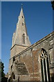
Nativity of Blessed Virgin Mary, Ringstead
Image: © Dave Kelly
Taken: 13 Sep 2003
0.08 miles
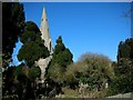
3
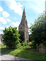
Church of the Nativity of the Blessed Virgin Mary, Ringstead
The church is mostly C13. It was restored in 1863.
Image: © Bikeboy
Taken: 30 May 2015
0.08 miles