IMAGES TAKEN NEAR TO
Hunter Rise, KETTERING, NN14 3FG
Introduction
This page details the photographs taken nearby to Hunter Rise, NN14 3FG by members of the Geograph project.
The Geograph project started in 2005 with the aim of publishing, organising and preserving representative images for every square kilometre of Great Britain, Ireland and the Isle of Man.

There are currently over 7.5m images from over14,400 individuals and you can help contribute to the project by visiting https://www.geograph.org.uk
Image Map
Images are licensed for reuse under creativecommons.org/licenses/by-sa/2.0
Notes
- Clicking on the map will re-center to the selected point.
- The higher the marker number, the further away the image location is from the centre of the postcode.
Image Listing (6 Images Found)
Images are licensed for reuse under creativecommons.org/licenses/by-sa/2.0
Image
Details
Distance
2
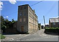
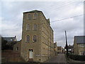
Wallis's Mill
A reminder that many of Northamptonshire's villages were once industrial centres rather than the dwelling place of commuters.
The mill was built in 1873-4 and its narrowness coupled with large windows ensured that the workspaces were well lit. https://historicengland.org.uk/listing/the-list/list-entry/1371974
Image: © Jonathan Thacker
Taken: 29 Jul 2019
0.11 miles
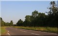
3
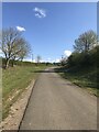
Old Dry Lane
Closed as a road by the building of the Brigstock bypass. Now a bridleway.
Image: © Jonathan Thacker
Taken: 29 Jul 2019
0.16 miles
5
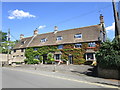
44 and 46 High Street, Brigstock
No. 44 (on the right) is the former New Inn and dates from about 1700 https://historicengland.org.uk/listing/the-list/list-entry/1294263. The adjacent No. 46 is a little younger https://historicengland.org.uk/listing/the-list/list-entry/1371953
Image: © Jonathan Thacker
Taken: 29 Jul 2019
0.19 miles