IMAGES TAKEN NEAR TO
Farm Close, KETTERING, NN14 3EF
Introduction
This page details the photographs taken nearby to Farm Close, NN14 3EF by members of the Geograph project.
The Geograph project started in 2005 with the aim of publishing, organising and preserving representative images for every square kilometre of Great Britain, Ireland and the Isle of Man.

There are currently over 7.5m images from over14,400 individuals and you can help contribute to the project by visiting https://www.geograph.org.uk
Image Map (Loading...)


Getting Data...Please wait
Leaflet Map data © OpenStreetMap
Images are licensed for reuse under creativecommons.org/licenses/by-sa/2.0
Notes
- Clicking on the map will re-center to the selected point.
- The higher the marker number, the further away the image location is from the centre of the postcode.
Image Listing (74 Images Found)
Images are licensed for reuse under creativecommons.org/licenses/by-sa/2.0
Image
Details
Distance
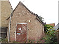
1
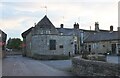
The Three Cocks, Brigstock
From the rear.
Image: © David Howard
Taken: 7 Sep 2023
0.03 miles
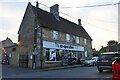
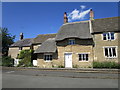
4
44 and 46 High Street, Brigstock
No. 44 (on the right) is the former New Inn and dates from about 1700 https://historicengland.org.uk/listing/the-list/list-entry/1294263. The adjacent No. 46 is a little younger https://historicengland.org.uk/listing/the-list/list-entry/1371953
Image: © Jonathan Thacker
Taken: 29 Jul 2019
0.05 miles
5
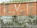
Marks on a wall in Brigstock
I believe this is some wartime marking for some service but needs confirming when moderated. An update with the assisistance of the local history society and a geographer suggest this is a V for victory painted on the wall soon after VE day (8th May 1945). It was painted by the village barber and the garage owner who both had premises nearby.
Image: © Michael Trolove
Taken: 9 Oct 2011
0.07 miles
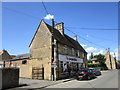
6
Brigstock Telephone Exchange
Located in Latham Street, this redbrick building has the code EMBRIGS and supplies telephone and broadband services to 600 residential and 32 non-residential premises in the Brigstock area. The pink flower in front of the TE is Red Valerian which grows out on tall stems from old walls and roadside verges. It flowers between May and October, and is a good source of nectar for bees, butterflies and moths. The numbering range of this TE is (01536) 37xxxx, the (01536) referring to the Kettering group of ten TEs, and its postcode is NN14 3HD.
Image: © David Hillas
Taken: 15 Jul 2019
0.07 miles
7
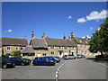
Brigstock: a corner of the market place
In the late middle ages Brigstock was the biggest settlement in Rockingham Forest and there were (from 1466) Saturday and (from 1604) Thursday Markets, and fairs on St George’s, St Bartholomew’s, St Mark’s and St Martin’s Days. These died out in the late 19th century. The market cross - see Image] and Image] - is ancient and carved with various initials and dates. This is a view of the fine houses on the corner of the market place and Stable Hill. The sharp turn to the left leads out of Brigstock to the A6116 and Corby. For more about the village, see http://www.brigstock.net/
Image: © John Sutton
Taken: 1 Jun 2011
0.08 miles
8
Brigstock: eighteenth-century houses
Fine masonry on the Mill Lane side of the Market Place. In the late middle ages Brigstock was the largest settlement in Rockingham Forest, and is still the largest parish. These grand houses are evidence of later prosperity.
Image: © John Sutton
Taken: 1 Jun 2011
0.09 miles
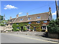
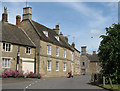
9
Hall Hill, Brigstock, west side
Hall Hill would once have been Brigstock's market place.
Image: © Jonathan Thacker
Taken: 29 Jul 2019
0.10 miles
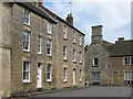
10
No 12, Hall Hill, Brigstock
Early eighteenth century cottage https://historicengland.org.uk/listing/the-list/list-entry/1371952
Image: © Jonathan Thacker
Taken: 29 Jul 2019
0.10 miles