IMAGES TAKEN NEAR TO
Twywell, KETTERING, NN14 3AL
Introduction
This page details the photographs taken nearby to NN14 3AL by members of the Geograph project.
The Geograph project started in 2005 with the aim of publishing, organising and preserving representative images for every square kilometre of Great Britain, Ireland and the Isle of Man.

There are currently over 7.5m images from over14,400 individuals and you can help contribute to the project by visiting https://www.geograph.org.uk
Image Map
Images are licensed for reuse under creativecommons.org/licenses/by-sa/2.0
Notes
- Clicking on the map will re-center to the selected point.
- The higher the marker number, the further away the image location is from the centre of the postcode.
Image Listing (6 Images Found)
Images are licensed for reuse under creativecommons.org/licenses/by-sa/2.0
Image
Details
Distance
1
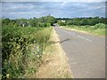
Former Main Road near Woodford
This used to be the A604, but was superseded by the A14. In the distance it can be seen to rise over a bridge of the former Kettering to Huntingdon railway.
Image: © Will Lovell
Taken: 22 Jun 2006
0.08 miles
4
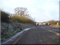
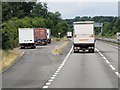
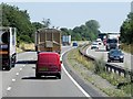
Layby on A14 westbound
Taken early on a very frosty January morning. One of the nice things about winter is the way you can clearly see the structure of the trees, like the group on the left.
Image: © Antony Dixon
Taken: 17 Jan 2012
0.14 miles