IMAGES TAKEN NEAR TO
Eagle Avenue, KETTERING, NN14 2WD
Introduction
This page details the photographs taken nearby to Eagle Avenue, NN14 2WD by members of the Geograph project.
The Geograph project started in 2005 with the aim of publishing, organising and preserving representative images for every square kilometre of Great Britain, Ireland and the Isle of Man.

There are currently over 7.5m images from over14,400 individuals and you can help contribute to the project by visiting https://www.geograph.org.uk
Image Map
Images are licensed for reuse under creativecommons.org/licenses/by-sa/2.0
Notes
- Clicking on the map will re-center to the selected point.
- The higher the marker number, the further away the image location is from the centre of the postcode.
Image Listing (6 Images Found)
Images are licensed for reuse under creativecommons.org/licenses/by-sa/2.0
Image
Details
Distance
2
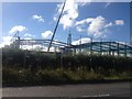
Building Site.
Major building expansion on the edge of Desborough.
Image: © Richard Williams
Taken: 21 Mar 2007
0.16 miles
3
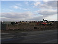
Road into Desborough.
B576 road (the old A6) passes factories on the outskirts of Desborough.
Image: © Richard Williams
Taken: 9 Mar 2007
0.18 miles
4
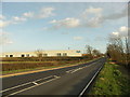
Desborough, Magnetic Park
Trading estate on Bear Way, at the junction of B576 and B669: http://www.lsh.co.uk/commercial-properties/freehold-leasehold/hotels-and-leisure-showroom-general-industrial-land/magnetic-park-kettering-nn14-2wb-390?currency=1
Image: © Mike Faherty
Taken: 9 May 2014
0.19 miles
5
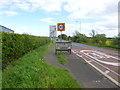
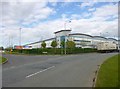
Desborough, road signs
On B576 with speed limit and town entry signs; in the distance, destination sign at the B669 junction.
Image: © Mike Faherty
Taken: 9 May 2014
0.20 miles
6
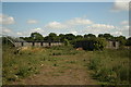
BCF Accommodation Huts
Airmen's Accommodation huts on the former dispersed site 4 RAF Desborough.
Image: © Chris Lowe
Taken: 8 Aug 2010
0.20 miles