IMAGES TAKEN NEAR TO
Broadlands, KETTERING, NN14 2QG
Introduction
This page details the photographs taken nearby to Broadlands, NN14 2QG by members of the Geograph project.
The Geograph project started in 2005 with the aim of publishing, organising and preserving representative images for every square kilometre of Great Britain, Ireland and the Isle of Man.

There are currently over 7.5m images from over14,400 individuals and you can help contribute to the project by visiting https://www.geograph.org.uk
Image Map (8 Images)


Getting Data...Please wait
Leaflet Map data © OpenStreetMap
Images are licensed for reuse under creativecommons.org/licenses/by-sa/2.0
Notes
- Clicking on the map will re-center to the selected point.
- The higher the marker number, the further away the image location is from the centre of the postcode.
Image Listing (8 Images Found)
Images are licensed for reuse under creativecommons.org/licenses/by-sa/2.0
Image
Details
Distance
1
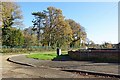
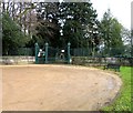
Desborough-Broadlands
Looking towards the cemetery perimeter fence.
Image: © Ian Rob
Taken: 4 Nov 2020
0.08 miles
8
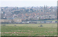
Desborough with its Leisure Centre from field near Rothwell
Image: © Peter Watkins
Taken: 16 Mar 2006
0.18 miles