IMAGES TAKEN NEAR TO
Woodwell Hill, KETTERING, NN14 2PE
Introduction
This page details the photographs taken nearby to Woodwell Hill, NN14 2PE by members of the Geograph project.
The Geograph project started in 2005 with the aim of publishing, organising and preserving representative images for every square kilometre of Great Britain, Ireland and the Isle of Man.

There are currently over 7.5m images from over14,400 individuals and you can help contribute to the project by visiting https://www.geograph.org.uk
Image Map
Images are licensed for reuse under creativecommons.org/licenses/by-sa/2.0
Notes
- Clicking on the map will re-center to the selected point.
- The higher the marker number, the further away the image location is from the centre of the postcode.
Image Listing (5 Images Found)
Images are licensed for reuse under creativecommons.org/licenses/by-sa/2.0
Image
Details
Distance
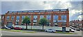
2
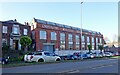
Desborough-Former Corset Factory
Still engaged in a similar business.
Image: © Ian Rob
Taken: 4 Nov 2020
0.22 miles
3
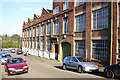
Eveden Limited factory.
Originally the CWS Corsetry Factory, Eveden Limited acquired the premises in 1989/90. Eveden Ltd. manufacture lingerie. This view of the north-west side of the factory was taken in Federation Avenue looking towards the B576.
Image: © Richard Dear
Taken: 5 Apr 2007
0.22 miles
4
Former Co-operative Wholesale Society Corset Factory, Desborough
Now owned by Wacoal Europe, the factory still produces lingerie and underwear.
The surrounding streets pick up the Cooperative theme: the street visible up the side of the factory on the right is Federation Avenue, to the other side is Pioneer Avenue, and linking them is Unity Street.
Image: © Christopher Hilton
Taken: 12 Jul 2023
0.23 miles