IMAGES TAKEN NEAR TO
Addison Road, KETTERING, NN14 2NN
Introduction
This page details the photographs taken nearby to Addison Road, NN14 2NN by members of the Geograph project.
The Geograph project started in 2005 with the aim of publishing, organising and preserving representative images for every square kilometre of Great Britain, Ireland and the Isle of Man.

There are currently over 7.5m images from over14,400 individuals and you can help contribute to the project by visiting https://www.geograph.org.uk
Image Map (Loading...)


Getting Data...Please wait
Leaflet Map data © OpenStreetMap
Images are licensed for reuse under creativecommons.org/licenses/by-sa/2.0
Notes
- Clicking on the map will re-center to the selected point.
- The higher the marker number, the further away the image location is from the centre of the postcode.
Image Listing (21 Images Found)
Images are licensed for reuse under creativecommons.org/licenses/by-sa/2.0
Image
Details
Distance
1
Desborough, Bonham's
At the corner of Gold Street and Harrington Road - left, hair salon, right, barber's shop.
Image: © Mike Faherty
Taken: 9 May 2014
0.13 miles
4
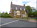
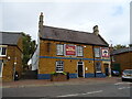
Desborough, Kings Arms
Newly refurbished pub at the corner of Harborough Road and High Street; bar to right, drinking and eating areas front and back, terrace, games machine, pool, darts. Cask ales on offer at my visit: Greene King IPA, Sharp's Doom Bar. For some customer comments (under its previous name, Oak Tree), see http://www.beerintheevening.com/pubs/s/26/26271/Oak_Tree/Desborough
Image: © Mike Faherty
Taken: 9 May 2014
0.20 miles
5

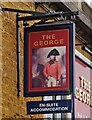
Desborough-Costa
Formerly The Oak Tree Public House.
Image: © Ian Rob
Taken: 4 Nov 2020
0.21 miles
6
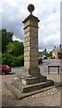
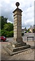
Old Milestone, by High Street, Desborough
Carved stone post by the UC road (was A6), in parish of DESBOROUGH (KETTERING District), junction of High Street, Buckwell Close and Station Road, on pavement in front of shops, on West side of road. Erected by the Market Harborough & Brampton turnpike trust in the 19th century.
Inscription reads:-
: To / Harbro / 5 : : To / Kettering / 6. : : 81 / Miles from / LONDON. :
Carved benchmark lower West face.
Grade II Listed. List Entry Number: 1213545
https://historicengland.org.uk/listing/the-list/list-entry/1213545
Milestone Society National ID: NR_KEMH06.
Image: © Helen Crabtree
Taken: 9 May 2014
0.22 miles
7
Old milestone beside High Street
See https://www.geograph.org.uk/photo/6045665
Image: © JThomas
Taken: 27 Sep 2022
0.22 miles
8
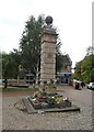
Desborough, milestone
Once one of a pair at a country house, adapted to become a milestone many years ago, and relocated to the corner of High Street and Station Road. Over the years the inscription eroded, to become almost illegible - distances to London (81), (Market) Harbro (5) and Kettering (6). Local members of the Milestone Society (http://www.milestonesociety.co.uk/ ) are paying for its professional refurbishment - one face is finished. The stone is listed by English Heritage: http://www.imagesofengland.org.uk/details/default.aspx?id=398166
Image: © Mike Faherty
Taken: 9 May 2014
0.22 miles