IMAGES TAKEN NEAR TO
Church Close, KETTERING, NN14 1SB
Introduction
This page details the photographs taken nearby to Church Close, NN14 1SB by members of the Geograph project.
The Geograph project started in 2005 with the aim of publishing, organising and preserving representative images for every square kilometre of Great Britain, Ireland and the Isle of Man.

There are currently over 7.5m images from over14,400 individuals and you can help contribute to the project by visiting https://www.geograph.org.uk
Image Map
Images are licensed for reuse under creativecommons.org/licenses/by-sa/2.0
Notes
- Clicking on the map will re-center to the selected point.
- The higher the marker number, the further away the image location is from the centre of the postcode.
Image Listing (45 Images Found)
Images are licensed for reuse under creativecommons.org/licenses/by-sa/2.0
Image
Details
Distance
1
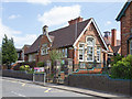
Rushton Primary School
The primary school on Station Road. https://enablecloud.lpplus.net/primary/rushton/Pages/RushtonPrimarySchool.aspx
A carved stone plaque on the front of the building reads "Rushton Board School AD 1892".
Image: © David P Howard
Taken: 6 May 2013
0.01 miles
2
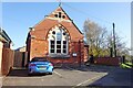
Rushton Village Hall
Former Primitive Methodist Chapel dating from 1904.
Image: © Ian Rob
Taken: 4 Nov 2020
0.03 miles
3
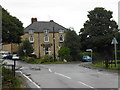
The Thornhill Arms
Pub at the junction of High Street and Station Road Rushton.
Image: © Jim Smillie
Taken: 1 Aug 2009
0.06 miles
4
Station Road Rushton
From beside the railway bridge.
Image: © Jim Smillie
Taken: 1 Aug 2009
0.06 miles
6
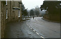
Station Road, Rushton
A cyclist passes the Thornhill Arms and approaches All Saints' Church on a murky January day.
Image: © Stephen McKay
Taken: Unknown
0.07 miles
7

Glendon and Rushton Station
A disused station building on the Midland Main Line just north out of Rushton village. The Friends of Glendon and Rushton Station, a group of 40 volunteers has taken over the building and hope to transform it into a railway museum, cafe and shop. http://www.northantstelegraph.co.uk/community/derelict-station-could-be-returned-to-former-glory-1-2341930
It is grade 2 listed. http://www.britishlistedbuildings.co.uk/en-231155-former-rushton-station-and-attached-stat
Image: © David P Howard
Taken: 6 May 2013
0.07 miles
8
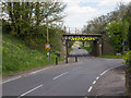
Railway bridge on Station Road
Midland Main Line railway bridge at the junction of Station Road and Manor Road.
Image: © David P Howard
Taken: 6 May 2013
0.09 miles
9
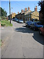
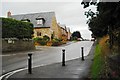
High Street, Rushton
The scourge of modern life … a charming narrow village street congested with parked cars. Most people walked when these cottages were built.
Image: © Kate Jewell
Taken: 4 Sep 2005
0.09 miles
10
Manor Road Rushton
The road to the right signposted 'Bridleway to Kettering'.
Image: © Jim Smillie
Taken: 1 Aug 2009
0.09 miles