IMAGES TAKEN NEAR TO
Pipewell, KETTERING, NN14 1QU
Introduction
This page details the photographs taken nearby to NN14 1QU by members of the Geograph project.
The Geograph project started in 2005 with the aim of publishing, organising and preserving representative images for every square kilometre of Great Britain, Ireland and the Isle of Man.

There are currently over 7.5m images from over14,400 individuals and you can help contribute to the project by visiting https://www.geograph.org.uk
Image Map
Images are licensed for reuse under creativecommons.org/licenses/by-sa/2.0
Notes
- Clicking on the map will re-center to the selected point.
- The higher the marker number, the further away the image location is from the centre of the postcode.
Image Listing (3 Images Found)
Images are licensed for reuse under creativecommons.org/licenses/by-sa/2.0
Image
Details
Distance
1
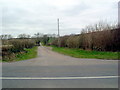
Track off Pipewell road
Leads to Upper Lodge
Image: © Les Harvey
Taken: 4 Apr 2007
0.21 miles
3
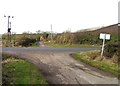
Track towards Pipewell Upper Lodge
No road names on the map! Right is to Pipwell and left us to Desborough.
Image: © Andrew Tatlow
Taken: 1 Feb 2010
0.24 miles