IMAGES TAKEN NEAR TO
Spencer Road, KETTERING, NN14 1DP
Introduction
This page details the photographs taken nearby to Spencer Road, NN14 1DP by members of the Geograph project.
The Geograph project started in 2005 with the aim of publishing, organising and preserving representative images for every square kilometre of Great Britain, Ireland and the Isle of Man.

There are currently over 7.5m images from over14,400 individuals and you can help contribute to the project by visiting https://www.geograph.org.uk
Image Map
Images are licensed for reuse under creativecommons.org/licenses/by-sa/2.0
Notes
- Clicking on the map will re-center to the selected point.
- The higher the marker number, the further away the image location is from the centre of the postcode.
Image Listing (15 Images Found)
Images are licensed for reuse under creativecommons.org/licenses/by-sa/2.0
Image
Details
Distance
1
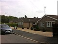
Warren Lane
1960s bungalows in Stanion.
Image: © Burgess Von Thunen
Taken: 23 Aug 2013
0.04 miles
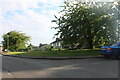
8
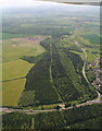
Stanion, Cowthick Plantation: aerial 2015
Junction of A43 and a A6116 SE of Corby.
The line of paler trees is the course of a former railway.
Image: © Chris
Taken: 28 May 2015
0.20 miles
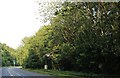
9
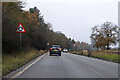
A43 Stamford Road
Left at the roundabout for Corby.
Image: © Robin Webster
Taken: 5 Dec 2021
0.20 miles