IMAGES TAKEN NEAR TO
Carey Street, NORTHAMPTON, NN1 3QN
Introduction
This page details the photographs taken nearby to Carey Street, NN1 3QN by members of the Geograph project.
The Geograph project started in 2005 with the aim of publishing, organising and preserving representative images for every square kilometre of Great Britain, Ireland and the Isle of Man.

There are currently over 7.5m images from over14,400 individuals and you can help contribute to the project by visiting https://www.geograph.org.uk
Image Map
Images are licensed for reuse under creativecommons.org/licenses/by-sa/2.0
Notes
- Clicking on the map will re-center to the selected point.
- The higher the marker number, the further away the image location is from the centre of the postcode.
Image Listing (60 Images Found)
Images are licensed for reuse under creativecommons.org/licenses/by-sa/2.0
Image
Details
Distance
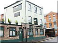
2
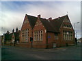
Kettering Road Music and Arts Centre
Formerly John Clare school.
Image: © Burgess Von Thunen
Taken: 18 May 2011
0.06 miles
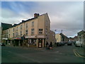
4
Spencer Road
Racial Equality Centre on the corner of Kettering Road.
Image: © Burgess Von Thunen
Taken: 18 May 2011
0.07 miles
5
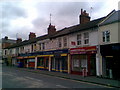
Kettering Road
Shops including an ethnic supermarket and letting agents.
Image: © Burgess Von Thunen
Taken: 15 Jun 2011
0.08 miles
6
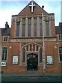
Mount Pleasant Baptist Church
Kettering Road in The Mounts.
Image: © Burgess Von Thunen
Taken: 18 May 2011
0.09 miles
7
Grove Road
Victorian terraces in The Mounts.
Image: © Burgess Von Thunen
Taken: 19 Nov 2015
0.09 miles
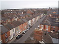
8
Kettering Road
Shops and houses in The Mounts.
Image: © Burgess Von Thunen
Taken: 18 May 2011
0.09 miles
10
Hood Street
Victorian terraces in The Mounts.
Image: © Burgess Von Thunen
Taken: 12 Aug 2013
0.10 miles