IMAGES TAKEN NEAR TO
Robinson Drive, BRACKLEY, NN13 6HF
Introduction
This page details the photographs taken nearby to Robinson Drive, NN13 6HF by members of the Geograph project.
The Geograph project started in 2005 with the aim of publishing, organising and preserving representative images for every square kilometre of Great Britain, Ireland and the Isle of Man.

There are currently over 7.5m images from over14,400 individuals and you can help contribute to the project by visiting https://www.geograph.org.uk
Image Map
Images are licensed for reuse under creativecommons.org/licenses/by-sa/2.0
Notes
- Clicking on the map will re-center to the selected point.
- The higher the marker number, the further away the image location is from the centre of the postcode.
Image Listing (28 Images Found)
Images are licensed for reuse under creativecommons.org/licenses/by-sa/2.0
Image
Details
Distance
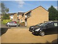
7
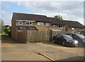
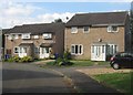
Residents parking - Bannerman Drive
No garages built with these houses, just a dusty/muddy rear shared area.
Image: © Fernweh
Taken: 10 Jul 2014
0.07 miles
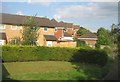
8
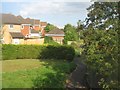
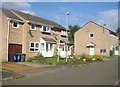
Suburban Brackley
Small gardens, winding paths, tightly packed houses. All so uninspiring.
Image: © Fernweh
Taken: 10 Jul 2014
0.07 miles