IMAGES TAKEN NEAR TO
Ariel Lane, BRACKLEY, NN13 6FR
Introduction
This page details the photographs taken nearby to Ariel Lane, NN13 6FR by members of the Geograph project.
The Geograph project started in 2005 with the aim of publishing, organising and preserving representative images for every square kilometre of Great Britain, Ireland and the Isle of Man.

There are currently over 7.5m images from over14,400 individuals and you can help contribute to the project by visiting https://www.geograph.org.uk
Image Map
Images are licensed for reuse under creativecommons.org/licenses/by-sa/2.0
Notes
- Clicking on the map will re-center to the selected point.
- The higher the marker number, the further away the image location is from the centre of the postcode.
Image Listing (3 Images Found)
Images are licensed for reuse under creativecommons.org/licenses/by-sa/2.0
Image
Details
Distance
1
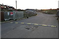
New developments on the edge of Brackley
Image: © Philip Jeffrey
Taken: 23 Sep 2018
0.22 miles
2
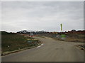
New developments on the edge of Brackley
Image: © Jonathan Thacker
Taken: 28 Apr 2017
0.23 miles
3
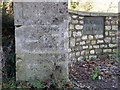
Cut mark on the gate post, Brackley
An OS Bench Mark cut into the stone post at the entrance to Brackley Grange.
Image: © Michael Trolove
Taken: 9 Jan 2011
0.24 miles