IMAGES TAKEN NEAR TO
Biddlesden, BRACKLEY, NN13 5TR
Introduction
This page details the photographs taken nearby to NN13 5TR by members of the Geograph project.
The Geograph project started in 2005 with the aim of publishing, organising and preserving representative images for every square kilometre of Great Britain, Ireland and the Isle of Man.

There are currently over 7.5m images from over14,400 individuals and you can help contribute to the project by visiting https://www.geograph.org.uk
Image Map
Images are licensed for reuse under creativecommons.org/licenses/by-sa/2.0
Notes
- Clicking on the map will re-center to the selected point.
- The higher the marker number, the further away the image location is from the centre of the postcode.
Image Listing (15 Images Found)
Images are licensed for reuse under creativecommons.org/licenses/by-sa/2.0
Image
Details
Distance
1
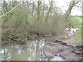
The Great Ouse at Biddlesden
View from Biddlesden Bridge of the river Great Ouse
Image: © Snidge
Taken: 16 Jan 2007
0.05 miles
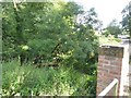
2
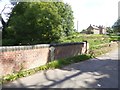
County boundary on Biddlesden Bridge
The bridge crosses the River Ouse and divides Northamptonshire and Buckinghamshire
Image: © David Smith
Taken: 25 Aug 2017
0.07 miles
4
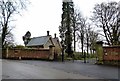
Biddlesden House Entrance
With ornate stone Lodge.
Image: © Ian Rob
Taken: 11 Dec 2015
0.10 miles
5
Track (footpath) to French's Barn, Biddlesden
Image: © David Smith
Taken: 25 Aug 2017
0.12 miles
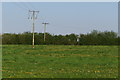
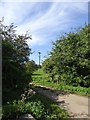
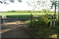
6
Track to Syresham Fields Farm
Part of the Ouse Valley Way.
Image: © Jonathan Thacker
Taken: 19 Apr 2017
0.15 miles
7
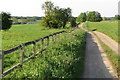
Ouse Valley Way going out of Biddlesden
Image: © Philip Jeffrey
Taken: 7 May 2018
0.17 miles
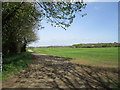
8
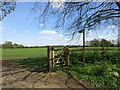
The beginning of a footpath to Syresham
Part of the Ouse Valley Way.
Image: © Jonathan Thacker
Taken: 19 Apr 2017
0.18 miles