IMAGES TAKEN NEAR TO
Farrer Close, BRACKLEY, NN13 5TG
Introduction
This page details the photographs taken nearby to Farrer Close, NN13 5TG by members of the Geograph project.
The Geograph project started in 2005 with the aim of publishing, organising and preserving representative images for every square kilometre of Great Britain, Ireland and the Isle of Man.

There are currently over 7.5m images from over14,400 individuals and you can help contribute to the project by visiting https://www.geograph.org.uk
Image Map
Images are licensed for reuse under creativecommons.org/licenses/by-sa/2.0
Notes
- Clicking on the map will re-center to the selected point.
- The higher the marker number, the further away the image location is from the centre of the postcode.
Image Listing (29 Images Found)
Images are licensed for reuse under creativecommons.org/licenses/by-sa/2.0
Image
Details
Distance
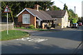
2
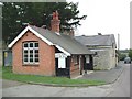
Whitfield Village Hall
The village hall in Whitfield
Image: © Snidge
Taken: 1 Feb 2007
0.03 miles
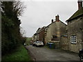
4
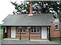
The Village Hall, Whitfield
The village hall in Whitfield
Image: © Snidge
Taken: 1 Feb 2007
0.03 miles
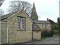
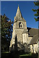
10
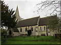
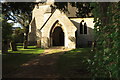
The church of St. John the Evangelist, Whitfield
Designed by Henry Woodyer 1869-70.
Image: © Jonathan Thacker
Taken: 29 Nov 2015
0.05 miles