IMAGES TAKEN NEAR TO
Field Way, BRACKLEY, NN13 5QN
Introduction
This page details the photographs taken nearby to Field Way, NN13 5QN by members of the Geograph project.
The Geograph project started in 2005 with the aim of publishing, organising and preserving representative images for every square kilometre of Great Britain, Ireland and the Isle of Man.

There are currently over 7.5m images from over14,400 individuals and you can help contribute to the project by visiting https://www.geograph.org.uk
Image Map
Images are licensed for reuse under creativecommons.org/licenses/by-sa/2.0
Notes
- Clicking on the map will re-center to the selected point.
- The higher the marker number, the further away the image location is from the centre of the postcode.
Image Listing (17 Images Found)
Images are licensed for reuse under creativecommons.org/licenses/by-sa/2.0
Image
Details
Distance

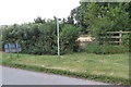
4
Footpath sign, Wappenham Road, Helmdon
Image: © Jonathan Thacker
Taken: 14 Jun 2016
0.07 miles
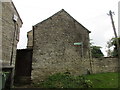
5
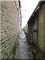
Footpath off Wappenham Road, Helmdon
Runs behind the houses then divides into three routes.
Image: © Jonathan Thacker
Taken: 14 Jun 2016
0.09 miles
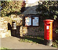
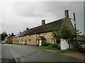
7

The Old Chapel, Helmdon
Now a house and by the looks of things considerably altered.
Image: © Jonathan Thacker
Taken: 14 Jun 2016
0.12 miles
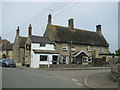
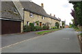
9
Cottages, Wappenham Road, Helmdon
The two closest are listed and date from the eighteenth century http://www.britishlistedbuildings.co.uk/en-234545-22-and-24-wappenham-road-helmdon-northam#.V9CEu0fkoeU
Image: © Jonathan Thacker
Taken: 14 Jun 2016
0.14 miles