IMAGES TAKEN NEAR TO
Church Street, BRACKLEY, NN13 5QJ
Introduction
This page details the photographs taken nearby to Church Street, NN13 5QJ by members of the Geograph project.
The Geograph project started in 2005 with the aim of publishing, organising and preserving representative images for every square kilometre of Great Britain, Ireland and the Isle of Man.

There are currently over 7.5m images from over14,400 individuals and you can help contribute to the project by visiting https://www.geograph.org.uk
Image Map
Images are licensed for reuse under creativecommons.org/licenses/by-sa/2.0
Notes
- Clicking on the map will re-center to the selected point.
- The higher the marker number, the further away the image location is from the centre of the postcode.
Image Listing (14 Images Found)
Images are licensed for reuse under creativecommons.org/licenses/by-sa/2.0
Image
Details
Distance
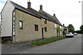
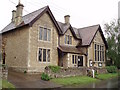
3
Stone Gables, Helmdon
A 17th century grade II listed building.
Image: © Robin Webster
Taken: 22 Aug 2020
0.16 miles
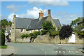
4
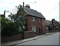
Helmdon Schoolhouse
The Schoolhouse next to the school which is still used.
Image: © Ian Rob
Taken: 4 Jun 2009
0.18 miles
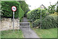
5
Helmdon Reading Room
This is used as the village hall.
Image: © Duncan Lilly
Taken: 10 May 2007
0.18 miles
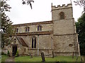
6
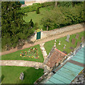
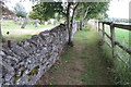
Helmdon churchyard from the church tower
This image shows the North porch and the entrance gate to the old vicarage.
Image: © Michael Barnes
Taken: 24 Apr 2005
0.19 miles
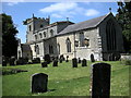
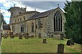
9
St Mary Magdalene Parish Church, Helmdon
Image: © Duncan Lilly
Taken: 10 May 2007
0.21 miles