IMAGES TAKEN NEAR TO
Welsh Lane, BRACKLEY, NN13 5QD
Introduction
This page details the photographs taken nearby to Welsh Lane, NN13 5QD by members of the Geograph project.
The Geograph project started in 2005 with the aim of publishing, organising and preserving representative images for every square kilometre of Great Britain, Ireland and the Isle of Man.

There are currently over 7.5m images from over14,400 individuals and you can help contribute to the project by visiting https://www.geograph.org.uk
Image Map
Images are licensed for reuse under creativecommons.org/licenses/by-sa/2.0
Notes
- Clicking on the map will re-center to the selected point.
- The higher the marker number, the further away the image location is from the centre of the postcode.
Image Listing (6 Images Found)
Images are licensed for reuse under creativecommons.org/licenses/by-sa/2.0
Image
Details
Distance
2
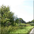
Footpath sign near Ash Vale
Little used because it is not linked to any other path where it meets the B4525 here
Image: © David Smith
Taken: 25 Aug 2017
0.09 miles
3
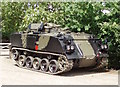
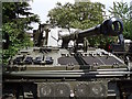
Not a tank?
Someone more expert than me will say this isn't a tank but a mobile armoured vehicle or something...
Image: © Duncan Lilly
Taken: 20 May 2007
0.13 miles
4
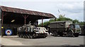
More vehicles and barn at Spring Farm
The large target seen in the barn is sometimes placed out on the roadside at the corner, facing east.
Image: © Duncan Lilly
Taken: 20 May 2007
0.14 miles
5
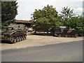
Tanks for the warning...
This gateway on a corner often has various large military vehicles parked outside. Bit of a surprise for drivers not expecting it!
It is home to the awfully punned Tanks-a-lot! (Website: http://www.tanks-alot.co.uk/ ). They operate tanks driving courses, corporate team building days and such like.
Image: © Duncan Lilly
Taken: 20 May 2007
0.14 miles
6
Definitely a tank...
Or maybe technically a mobile gun... Big, either way.
Image: © Duncan Lilly
Taken: 20 May 2007
0.15 miles