IMAGES TAKEN NEAR TO
Westbury, BRACKLEY, NN13 5JH
Introduction
This page details the photographs taken nearby to NN13 5JH by members of the Geograph project.
The Geograph project started in 2005 with the aim of publishing, organising and preserving representative images for every square kilometre of Great Britain, Ireland and the Isle of Man.

There are currently over 7.5m images from over14,400 individuals and you can help contribute to the project by visiting https://www.geograph.org.uk
Image Map
Images are licensed for reuse under creativecommons.org/licenses/by-sa/2.0
Notes
- Clicking on the map will re-center to the selected point.
- The higher the marker number, the further away the image location is from the centre of the postcode.
Image Listing (6 Images Found)
Images are licensed for reuse under creativecommons.org/licenses/by-sa/2.0
Image
Details
Distance
2
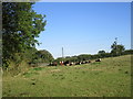
Cattle near Grove Farm
Leaving the footpath clear,
Image: © Jonathan Thacker
Taken: 10 Sep 2015
0.06 miles
3
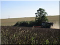
Harvesting beans
An especially dusty job.
Image: © Jonathan Thacker
Taken: 10 Sep 2015
0.09 miles
4
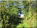
Gap in the hedge
On a footpath to Turweston.
Image: © Jonathan Thacker
Taken: 10 Sep 2015
0.20 miles
5
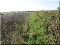
Overgrown footpath
Passable but clearly not much used. No doubt locked gates act as a deterrent.
Image: © Jonathan Thacker
Taken: 10 Sep 2015
0.24 miles
6
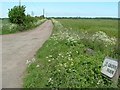
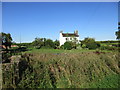
Track to Grove Farm
The track to Grove Farm.
Image: © Snidge
Taken: 22 May 2007
0.25 miles