IMAGES TAKEN NEAR TO
High Street, BRACKLEY, NN13 5HL
Introduction
This page details the photographs taken nearby to High Street, NN13 5HL by members of the Geograph project.
The Geograph project started in 2005 with the aim of publishing, organising and preserving representative images for every square kilometre of Great Britain, Ireland and the Isle of Man.

There are currently over 7.5m images from over14,400 individuals and you can help contribute to the project by visiting https://www.geograph.org.uk
Image Map
Images are licensed for reuse under creativecommons.org/licenses/by-sa/2.0
Notes
- Clicking on the map will re-center to the selected point.
- The higher the marker number, the further away the image location is from the centre of the postcode.
Image Listing (28 Images Found)
Images are licensed for reuse under creativecommons.org/licenses/by-sa/2.0
Image
Details
Distance
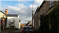
1
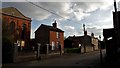
High Street, Syresham
The Methodist church faces across to a village hall.
Image: © Chris Brown
Taken: 5 Apr 2017
0.01 miles
2
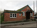
Syresham Sunday School
Dates from 1926.
Image: © Jonathan Thacker
Taken: 1 Dec 2015
0.01 miles
3
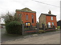
Methodist church, Syresham
The chapel (and probably the cottage at the side) was refronted in 1846. The red brick must have seen very daring in contrast with the local stone. Even 170 years later it comes as a bit of a shock.
Image: © Jonathan Thacker
Taken: 1 Dec 2015
0.01 miles
4
High Street, Syresham
Looking north-east at the Bell Lane junction and the village shop.
Image: © Chris Brown
Taken: 5 Apr 2017
0.03 miles
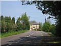
5
Bell Lane, Syresham
Looking south to the Methodist church on High Street.
Image: © Chris Brown
Taken: 5 Apr 2017
0.05 miles
7
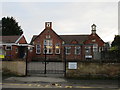
Syresham Primary School
Unusually has two bellcotes.
Image: © Jonathan Thacker
Taken: 1 Dec 2015
0.06 miles
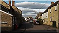
9
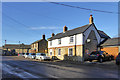
Houses, High Street, Syresham
This is the broadest part of the street, the rest, beyond the junction on the left, is narrower.
Image: © Robin Webster
Taken: 4 Dec 2016
0.08 miles
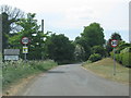
10
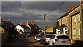
High Street, Syresham
The bend ahead is at the junction with Broad Street, which is less broad than High Street.
Image: © Chris Brown
Taken: 5 Apr 2017
0.09 miles