IMAGES TAKEN NEAR TO
Bradbery Close, BRACKLEY, NN13 5HA
Introduction
This page details the photographs taken nearby to Bradbery Close, NN13 5HA by members of the Geograph project.
The Geograph project started in 2005 with the aim of publishing, organising and preserving representative images for every square kilometre of Great Britain, Ireland and the Isle of Man.

There are currently over 7.5m images from over14,400 individuals and you can help contribute to the project by visiting https://www.geograph.org.uk
Image Map
Images are licensed for reuse under creativecommons.org/licenses/by-sa/2.0
Notes
- Clicking on the map will re-center to the selected point.
- The higher the marker number, the further away the image location is from the centre of the postcode.
Image Listing (26 Images Found)
Images are licensed for reuse under creativecommons.org/licenses/by-sa/2.0
Image
Details
Distance
3
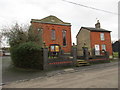
Methodist church, Syresham
The chapel (and probably the cottage at the side) was refronted in 1846. The red brick must have seen very daring in contrast with the local stone. Even 170 years later it comes as a bit of a shock.
Image: © Jonathan Thacker
Taken: 1 Dec 2015
0.11 miles
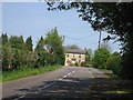
4
Houses on The Pound, Syresham
An addition to the old village to the west.
Image: © Robin Webster
Taken: 4 Dec 2016
0.11 miles
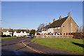
5
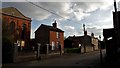
High Street, Syresham
The Methodist church faces across to a village hall.
Image: © Chris Brown
Taken: 5 Apr 2017
0.12 miles
6
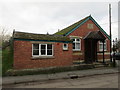
Syresham Sunday School
Dates from 1926.
Image: © Jonathan Thacker
Taken: 1 Dec 2015
0.12 miles
7
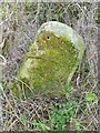
Old Milestone by Main Road, Syresham
Stone post (plate lost) off the A43, by Main Road in parish of SYRESHAM (SOUTH NORTHAMPTONSHIRE District), West of Syresham, by the road, on South side of road. Brackley tombstone and iron plate, erected by the Towcester, Brackley to Weston turnpike trust in the 19th century.
Inscription once read:-
(Towcester)
(7)
(Brackley)
(12)
Carved bench mark and rivet on top (unless destroyed)
Milestone Society National ID: NR_OXNH25.
Image: © EW Flaxman
Taken: 1 Apr 2000
0.13 miles
8
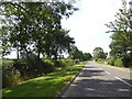
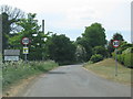
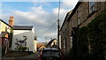
Main Road and village boundary west of Syresham
The village boundary is marked by white fences creating the appearance of a gated village. Main Road was formerly the A43, before the bypass was made
Image: © David Smith
Taken: 25 Aug 2017
0.13 miles
9
Bell Lane, Syresham
Looking south to the Methodist church on High Street.
Image: © Chris Brown
Taken: 5 Apr 2017
0.14 miles
10
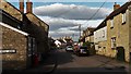
High Street, Syresham
Looking north-east at the Bell Lane junction and the village shop.
Image: © Chris Brown
Taken: 5 Apr 2017
0.16 miles