IMAGES TAKEN NEAR TO
Croughton, BRACKLEY, NN13 5GR
Introduction
This page details the photographs taken nearby to NN13 5GR by members of the Geograph project.
The Geograph project started in 2005 with the aim of publishing, organising and preserving representative images for every square kilometre of Great Britain, Ireland and the Isle of Man.

There are currently over 7.5m images from over14,400 individuals and you can help contribute to the project by visiting https://www.geograph.org.uk
Image Map
Images are licensed for reuse under creativecommons.org/licenses/by-sa/2.0
Notes
- Clicking on the map will re-center to the selected point.
- The higher the marker number, the further away the image location is from the centre of the postcode.
Image Listing (7 Images Found)
Images are licensed for reuse under creativecommons.org/licenses/by-sa/2.0
Image
Details
Distance
2
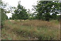
Strip of new woodland by Brackley Road
Image: © Philip Jeffrey
Taken: 19 Aug 2018
0.08 miles
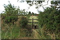
3
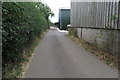
Bridleway and entrance to Gateridge farm
Image: © Philip Jeffrey
Taken: 19 Aug 2018
0.09 miles
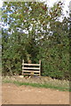

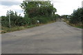
6
Stile and footpath towards Plomers Firs Farm
Interestingly the sign on the farm entrance calls it Plomers Furze Farm.
Image: © Philip Jeffrey
Taken: 19 Aug 2018
0.22 miles