IMAGES TAKEN NEAR TO
Lower Bath Street, NORTHAMPTON, NN1 2ST
Introduction
This page details the photographs taken nearby to Lower Bath Street, NN1 2ST by members of the Geograph project.
The Geograph project started in 2005 with the aim of publishing, organising and preserving representative images for every square kilometre of Great Britain, Ireland and the Isle of Man.

There are currently over 7.5m images from over14,400 individuals and you can help contribute to the project by visiting https://www.geograph.org.uk
Image Map
Images are licensed for reuse under creativecommons.org/licenses/by-sa/2.0
Notes
- Clicking on the map will re-center to the selected point.
- The higher the marker number, the further away the image location is from the centre of the postcode.
Image Listing (96 Images Found)
Images are licensed for reuse under creativecommons.org/licenses/by-sa/2.0
Image
Details
Distance
1
Castle Station
St Andrews Road entrance.
Image: © Burgess Von Thunen
Taken: 6 Sep 2011
0.06 miles
2
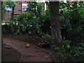
Cloisters Pocket Park, Spring Boroughs
The pocket park was undergoing a cosmetic facelift at this stage
Image: © Ruth Thomas
Taken: 29 Jun 2005
0.09 miles
3
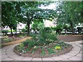
Cloister Pocket Park, Spring Boroughs after makeover 2005
The pocket park had been completely re landscaped
Image: © Ruth Thomas
Taken: 2 Jul 2005
0.09 miles
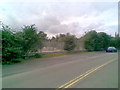
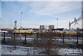
4
Lines off to the railway shed, Northampton
The railway shed had been demolished and replaced by a car park.
Image: © N Chadwick
Taken: 19 Dec 2010
0.09 miles
5
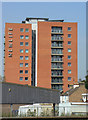
NEWLIFE (1)
Refurbished tower block off Mayor Hold.
Image: © Alan Murray-Rust
Taken: 3 Aug 2011
0.12 miles
6
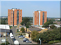
NEWLIFE (4)
The two tower blocks seen from the Mayorhold car park; Tower Street in the foreground. The blocks have been refurbished in partnership with LHA-ASRA http://www.lha-asra.org.uk/add/aboutus/Pages/Default.aspx to provide affordable properties for key workers.
Image: © Alan Murray-Rust
Taken: 3 Aug 2011
0.12 miles
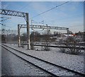
8
Northampton Railway Station
At weekends, Northampton is currently the northern terminus of all services from Euston. This is due to a major upgrade of the West Coast Mainline at Rugby where the line is closed every weekend for work to proceed. Passengers for more northerly destinations are transferred to appropriate intermediate stations by bus. The work at Rugby is currently planned to be completed in time for new timetables in December 2008 but doubts have recently been expressed about the ability of Network Rail to complete by then, so it may be Easter 2009 before the new timetable can be implemented.
Image: © John Lucas
Taken: 19 Jul 2008
0.14 miles
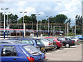
9

Car park, Northampton Station
View north west over the car park from up on St. Andrew's Road.
Image: © David P Howard
Taken: 26 Jun 2013
0.14 miles
10
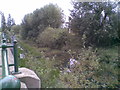
Victoria Park
A tributary of the River Nene flowing between flood defences adjacent to Victoria Park and the London Midland line from Northampton to Birmingham. The tributary flows from the north of the county through the Brampton Valley.
Image: © Burgess Von Thunen
Taken: 23 Aug 2011
0.14 miles