IMAGES TAKEN NEAR TO
The Jetty, TOWCESTER, NN12 8SR
Introduction
This page details the photographs taken nearby to The Jetty, NN12 8SR by members of the Geograph project.
The Geograph project started in 2005 with the aim of publishing, organising and preserving representative images for every square kilometre of Great Britain, Ireland and the Isle of Man.

There are currently over 7.5m images from over14,400 individuals and you can help contribute to the project by visiting https://www.geograph.org.uk
Image Map
Images are licensed for reuse under creativecommons.org/licenses/by-sa/2.0
Notes
- Clicking on the map will re-center to the selected point.
- The higher the marker number, the further away the image location is from the centre of the postcode.
Image Listing (15 Images Found)
Images are licensed for reuse under creativecommons.org/licenses/by-sa/2.0
Image
Details
Distance
1
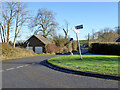
Road junction, Wappenham
Brookside meets the main road, which is called High Street to the left, if not right.
Image: © Robin Webster
Taken: 4 Dec 2016
0.05 miles
2
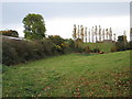
Poplar trees on the edge of Wappenham
Image: © Jonathan Thacker
Taken: 28 Oct 2016
0.08 miles
3
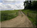
Steep Track
This steep farm track climbs up to farm buildings behind the trees.
Image: © Michael Patterson
Taken: 20 Jun 2006
0.14 miles
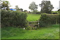
5
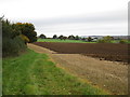
View towards Spring Hill
The footpath across this field has been ploughed so we're going round the edge (and about to get lost).
Image: © Jonathan Thacker
Taken: 28 Oct 2016
0.16 miles
6
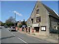
Wappenham village stores
Next to Wappenham Chapel - an evangelical church - to the left. Although there is no sign on the wall, a post office is contained within the shop.
Image: © Jonathan Billinger
Taken: 15 Apr 2008
0.17 miles
7
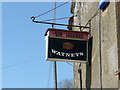
Watney's sign
An obsolete brew, but still signifies an off-licence at Wappenham village shop.
Image: © Jonathan Billinger
Taken: 15 Apr 2008
0.17 miles
8

Wappenham Village Stores
Unfortunately they have closed since Jonathan's images [http://www.geograph.org.uk/photo/772919]
Image: © Ian Rob
Taken: 7 Jul 2012
0.20 miles
9
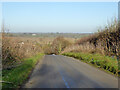
Wappenham Road dropping down to Wappenham
From the Syresham direction.
Image: © Robin Webster
Taken: 4 Dec 2016
0.21 miles
10

Wappenham Chapel
The former Wesleyan Chapel on High Street dates from 1860, it is now known as Slapton and Wappenham Independent Evangelical Church.
Image: © Ian Rob
Taken: 7 Jul 2012
0.21 miles