IMAGES TAKEN NEAR TO
Maidford Road, TOWCESTER, NN12 8JH
Introduction
This page details the photographs taken nearby to Maidford Road, NN12 8JH by members of the Geograph project.
The Geograph project started in 2005 with the aim of publishing, organising and preserving representative images for every square kilometre of Great Britain, Ireland and the Isle of Man.

There are currently over 7.5m images from over14,400 individuals and you can help contribute to the project by visiting https://www.geograph.org.uk
Image Map
Images are licensed for reuse under creativecommons.org/licenses/by-sa/2.0
Notes
- Clicking on the map will re-center to the selected point.
- The higher the marker number, the further away the image location is from the centre of the postcode.
Image Listing (5 Images Found)
Images are licensed for reuse under creativecommons.org/licenses/by-sa/2.0
Image
Details
Distance
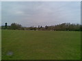
1

View towards Lane Close Farm, Litchborough
Image: © Robin Webster
Taken: 4 Dec 2016
0.08 miles
2
Farmland near Litchborough
Just off the road to Maidford.
Image: © Burgess Von Thunen
Taken: 6 Apr 2010
0.14 miles
3
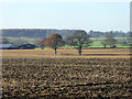
Two trees in a field
The remains of an old hedgerow.
Image: © Robin Webster
Taken: 4 Dec 2016
0.16 miles
4
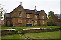
Houses on Banbury Road, Litchborough
Dated AWC 1870.
Image: © Ian S
Taken: 25 May 2016
0.21 miles
5

Barns across a ploughed field
Do they have a name?
Image: © Robin Webster
Taken: 4 Dec 2016
0.24 miles