IMAGES TAKEN NEAR TO
St. Johns Road, TOWCESTER, NN12 8AA
Introduction
This page details the photographs taken nearby to St. Johns Road, NN12 8AA by members of the Geograph project.
The Geograph project started in 2005 with the aim of publishing, organising and preserving representative images for every square kilometre of Great Britain, Ireland and the Isle of Man.

There are currently over 7.5m images from over14,400 individuals and you can help contribute to the project by visiting https://www.geograph.org.uk
Image Map
Images are licensed for reuse under creativecommons.org/licenses/by-sa/2.0
Notes
- Clicking on the map will re-center to the selected point.
- The higher the marker number, the further away the image location is from the centre of the postcode.
Image Listing (6 Images Found)
Images are licensed for reuse under creativecommons.org/licenses/by-sa/2.0
Image
Details
Distance
1
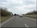
A43 approaches junction with St John's Road
Image: © Stuart Logan
Taken: 21 Feb 2013
0.06 miles
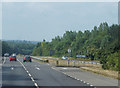
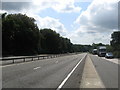
3
A43 towards Northampton
South of the M1.
Image: © Robin Webster
Taken: 23 Jun 2019
0.06 miles
4
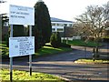
St John's Centre, Tiffield
St John's Centre is a Northamptonshire County Council Children & Family Service facility with its various functions listed on the notice by the gate.
Image: © Stephen McKay
Taken: 16 Dec 2006
0.10 miles
5
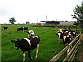
Top Farm
Minutes before the herd of cows all ran towards me and tried to knock the fence down.
Image: © Lisa Jarvis
Taken: 12 Jun 2007
0.21 miles
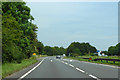
6
The A43 near St. John's Centre at Tiffield
Image: © James Denham
Taken: 7 Aug 2009
0.24 miles