IMAGES TAKEN NEAR TO
The Orchard, TOWCESTER, NN12 7UZ
Introduction
This page details the photographs taken nearby to The Orchard, NN12 7UZ by members of the Geograph project.
The Geograph project started in 2005 with the aim of publishing, organising and preserving representative images for every square kilometre of Great Britain, Ireland and the Isle of Man.

There are currently over 7.5m images from over14,400 individuals and you can help contribute to the project by visiting https://www.geograph.org.uk
Image Map
Images are licensed for reuse under creativecommons.org/licenses/by-sa/2.0
Notes
- Clicking on the map will re-center to the selected point.
- The higher the marker number, the further away the image location is from the centre of the postcode.
Image Listing (11 Images Found)
Images are licensed for reuse under creativecommons.org/licenses/by-sa/2.0
Image
Details
Distance
2
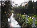
The brook in Potterspury
Off Blackwell End the brook in Potterspury
Image: © Shaun Ferguson
Taken: 2 Mar 2011
0.11 miles
5
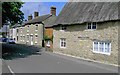
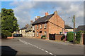
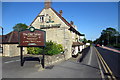
High Street, Potterspury 2007
A view of what was once the commercial hub of the village. The 17th century thatched house was once the village post office, wheelwright's, and undertaker's, while the early 19th century building next door was the village bakery until the early 1960s.
Image: © Judith Millidge
Taken: 18 May 2007
0.15 miles
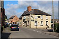
6
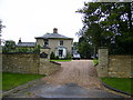
Prestigious home just off the A5 in Potterspury
Image: © Phil Catterall
Taken: 6 Oct 2006
0.16 miles