IMAGES TAKEN NEAR TO
Lime Road, TOWCESTER, NN12 7UJ
Introduction
This page details the photographs taken nearby to Lime Road, NN12 7UJ by members of the Geograph project.
The Geograph project started in 2005 with the aim of publishing, organising and preserving representative images for every square kilometre of Great Britain, Ireland and the Isle of Man.

There are currently over 7.5m images from over14,400 individuals and you can help contribute to the project by visiting https://www.geograph.org.uk
Image Map (Loading...)


Getting Data...Please wait
Leaflet Map data © OpenStreetMap
Images are licensed for reuse under creativecommons.org/licenses/by-sa/2.0
Notes
- Clicking on the map will re-center to the selected point.
- The higher the marker number, the further away the image location is from the centre of the postcode.
Image Listing (4 Images Found)
Images are licensed for reuse under creativecommons.org/licenses/by-sa/2.0
Image
Details
Distance
1
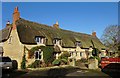
Yardley Gobion-Moorend Road
Large thatched house.
Image: © Ian Rob
Taken: 29 Nov 2019
0.11 miles
2
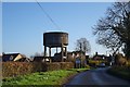
Yardley Gobion Water Tower
On the western edge of the village
Image: © Ian Rob
Taken: 29 Nov 2019
0.15 miles
3
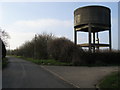
Water tower
Water tower off Moorend Road
Image: © Shaun Ferguson
Taken: 2 Mar 2011
0.15 miles
4
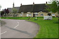
Yardley Gobion green and thatched cottages
Image: © Philip Jeffrey
Taken: 20 May 2012
0.24 miles