IMAGES TAKEN NEAR TO
Ashton Road, TOWCESTER, NN12 7SL
Introduction
This page details the photographs taken nearby to Ashton Road, NN12 7SL by members of the Geograph project.
The Geograph project started in 2005 with the aim of publishing, organising and preserving representative images for every square kilometre of Great Britain, Ireland and the Isle of Man.

There are currently over 7.5m images from over14,400 individuals and you can help contribute to the project by visiting https://www.geograph.org.uk
Image Map
Images are licensed for reuse under creativecommons.org/licenses/by-sa/2.0
Notes
- Clicking on the map will re-center to the selected point.
- The higher the marker number, the further away the image location is from the centre of the postcode.
Image Listing (12 Images Found)
Images are licensed for reuse under creativecommons.org/licenses/by-sa/2.0
Image
Details
Distance
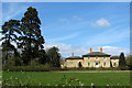
2

House on Northampton Road, Stoke Bruerne
Image: © David Howard
Taken: 2 Aug 2022
0.04 miles
3

House entrance on Northampton Road, Stoke Bruerne
Image: © David Howard
Taken: 2 Aug 2022
0.05 miles
4
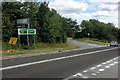
A508 Northampton Road near to Stoke Bruerne
Image: © David Dixon
Taken: 19 Aug 2018
0.06 miles
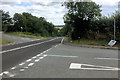
5
Crossroads on the A508 east of Stoke Bruerne
Image: © Phil Catterall
Taken: 5 Oct 2006
0.07 miles
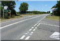
7
Rookery Lane/Northampton Road/Ashton Road Crossroads
Image: © David Dixon
Taken: 19 Aug 2018
0.08 miles
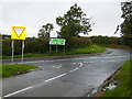
8
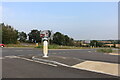
Rookery Lane meets the A508, Stoke Bruerne
This junction has just been upgraded. It has been widened and added an island here.
Image: © David Howard
Taken: 1 Sep 2024
0.08 miles
10
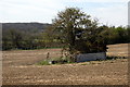
Tree and shelter amid the arable field
Image: © Philip Jeffrey
Taken: 23 Apr 2013
0.14 miles