IMAGES TAKEN NEAR TO
Furtho Lane, TOWCESTER, NN12 7PZ
Introduction
This page details the photographs taken nearby to Furtho Lane, NN12 7PZ by members of the Geograph project.
The Geograph project started in 2005 with the aim of publishing, organising and preserving representative images for every square kilometre of Great Britain, Ireland and the Isle of Man.

There are currently over 7.5m images from over14,400 individuals and you can help contribute to the project by visiting https://www.geograph.org.uk
Image Map
Images are licensed for reuse under creativecommons.org/licenses/by-sa/2.0
Notes
- Clicking on the map will re-center to the selected point.
- The higher the marker number, the further away the image location is from the centre of the postcode.
Image Listing (18 Images Found)
Images are licensed for reuse under creativecommons.org/licenses/by-sa/2.0
Image
Details
Distance
3
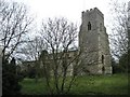
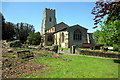
Potterspury Church
Saint Nicholas Church on a slightly elevated position.
Image: © Ian Rob
Taken: 5 Apr 2010
0.13 miles
4
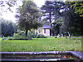
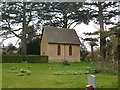
Cemetery and Chapel in the grounds at Potterspury
Image: © Phil Catterall
Taken: 6 Oct 2006
0.14 miles
7
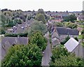
Church Lane, Potterspury, looking south-west.
A view of Potterspury from the top of St Nicholas Church tower, September 2004.
Image: © Judith Millidge
Taken: 6 Sep 2004
0.14 miles
9
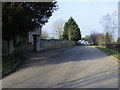
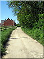
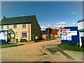
Poundfield Road
Poundfield Road by Potterspury House
Image: © Shaun Ferguson
Taken: 2 Mar 2011
0.16 miles
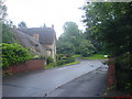
10
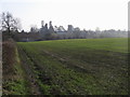
Looking to St Nicholas church Potterspury
From Yardley Road looking to St Nicholas church Potterspury
Image: © Shaun Ferguson
Taken: 2 Mar 2011
0.16 miles