IMAGES TAKEN NEAR TO
Spring Lane, TOWCESTER, NN12 7LW
Introduction
This page details the photographs taken nearby to Spring Lane, NN12 7LW by members of the Geograph project.
The Geograph project started in 2005 with the aim of publishing, organising and preserving representative images for every square kilometre of Great Britain, Ireland and the Isle of Man.

There are currently over 7.5m images from over14,400 individuals and you can help contribute to the project by visiting https://www.geograph.org.uk
Image Map
Images are licensed for reuse under creativecommons.org/licenses/by-sa/2.0
Notes
- Clicking on the map will re-center to the selected point.
- The higher the marker number, the further away the image location is from the centre of the postcode.
Image Listing (22 Images Found)
Images are licensed for reuse under creativecommons.org/licenses/by-sa/2.0
Image
Details
Distance


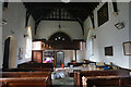
3
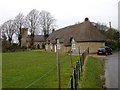
Alderton
A cottage known as the Round Cottage and the church of Saint Margaret in the background.
Image: © Ian Rob
Taken: 20 Feb 2007
0.09 miles

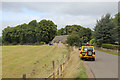
5
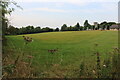
Field by Pury Road, Alderton
St Margaret's Church is on the right.
Image: © David Howard
Taken: 1 Sep 2024
0.10 miles
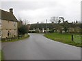
6
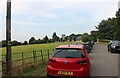
Pury Road, Alderton
St Margaret's Church tower is in the background.
Image: © David Howard
Taken: 1 Sep 2024
0.10 miles
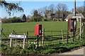
10
Alderton
Thatched Cottages at the south end of the village.
Image: © Ian Rob
Taken: 20 Feb 2007
0.12 miles