IMAGES TAKEN NEAR TO
Pomfret Road, TOWCESTER, NN12 6ET
Introduction
This page details the photographs taken nearby to Pomfret Road, NN12 6ET by members of the Geograph project.
The Geograph project started in 2005 with the aim of publishing, organising and preserving representative images for every square kilometre of Great Britain, Ireland and the Isle of Man.

There are currently over 7.5m images from over14,400 individuals and you can help contribute to the project by visiting https://www.geograph.org.uk
Image Map
Images are licensed for reuse under creativecommons.org/licenses/by-sa/2.0
Notes
- Clicking on the map will re-center to the selected point.
- The higher the marker number, the further away the image location is from the centre of the postcode.
Image Listing (167 Images Found)
Images are licensed for reuse under creativecommons.org/licenses/by-sa/2.0
Image
Details
Distance
1
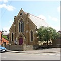
Methodist Chapel, Brackley Road, Towcester
Dated 1893.
Image: © Humphrey Bolton
Taken: 1 Jun 2007
0.01 miles
2
Rear of Methodist Chapel, Brackley Road, Towcester
Showing the rose window.
Image: © Humphrey Bolton
Taken: 1 Jun 2007
0.01 miles
3
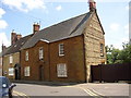
21 and 23 Park Street, Towcester
21 on the left is the Old Mint House, built of limestone in the early 17C but altered in the 19C and 20C. 23 is also 17C, but was refronted in ironstone ashlar c.1840. The doorway has Doric pilasters supporting the pediment.
Image: © Humphrey Bolton
Taken: 1 Jun 2007
0.06 miles
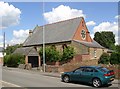
4
The Oddfellows Hall, Brackley Road, Towcester
The Oddfellows friendly society is still going strong, and are currently recruiting members. Halls like this were built so that members could meet for social events. This one is dated 1932.
Image: © Humphrey Bolton
Taken: 1 Jun 2007
0.06 miles
5
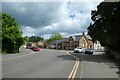
Brackley Road near Park Street
Looking towards the junction of Park Street with Brackley Road in Towcester.
Image: © DS Pugh
Taken: 29 May 2022
0.08 miles
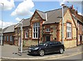
6
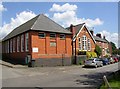
The Library, Richmond Road, Towcester
A plaque on the wall (see other photograph) indicates that this building was a Church of England School, built in 1869 and extended in 1929.
Image: © Humphrey Bolton
Taken: 1 Jun 2007
0.09 miles
7
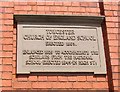
Plaque on the Library, Richmond Road, Towcester
Image: © Humphrey Bolton
Taken: 1 Jun 2007
0.09 miles
8
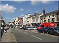
Watling Street West, Towcester
The shopping street of the town is also the A5, still busy despite the nearby M1 motorway.
Image: © Humphrey Bolton
Taken: 1 Jun 2007
0.09 miles
9
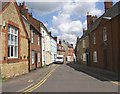
Park Street, Towcester
This is a narrow street linking Brackley Road with Watling Street West. It has many listed buildings of the 17C to 19C. The gable-end of the Oddfellows Hall is on the left.
Image: © Humphrey Bolton
Taken: 1 Jun 2007
0.09 miles
10
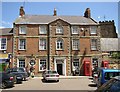
Post Office, Towcester
Many town centre post offices were built in neo-Georgian style in the mid-20C, but this one is genuine Georgian, dated 1799. It was built as a house.
Image: © Humphrey Bolton
Taken: 1 Jun 2007
0.09 miles