IMAGES TAKEN NEAR TO
Bairstow Road, TOWCESTER, NN12 6EF
Introduction
This page details the photographs taken nearby to Bairstow Road, NN12 6EF by members of the Geograph project.
The Geograph project started in 2005 with the aim of publishing, organising and preserving representative images for every square kilometre of Great Britain, Ireland and the Isle of Man.

There are currently over 7.5m images from over14,400 individuals and you can help contribute to the project by visiting https://www.geograph.org.uk
Image Map
Images are licensed for reuse under creativecommons.org/licenses/by-sa/2.0
Notes
- Clicking on the map will re-center to the selected point.
- The higher the marker number, the further away the image location is from the centre of the postcode.
Image Listing (23 Images Found)
Images are licensed for reuse under creativecommons.org/licenses/by-sa/2.0
Image
Details
Distance
1

Towcester and Towcester Racecourse: aerial 2015
A5 Watling Street running to the top centre, and Easton Neston Park left.
Image: © Chris
Taken: 28 May 2015
0.16 miles
2
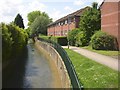
Stream off Watling Street, Towcester
An urban stream with concrete walls, unusually clean.
Image: © Humphrey Bolton
Taken: 1 Jun 2007
0.17 miles
3
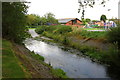
Silverstone Brook and recreation ground
Image: © Philip Jeffrey
Taken: 5 Aug 2012
0.18 miles
4
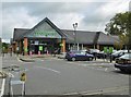
Towcester, Waitrose
Superstore on Richmond Road: https://www.waitrose.com/bf_home/bf/682.html
Image: © Mike Faherty
Taken: 6 Oct 2019
0.20 miles
6
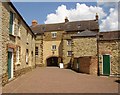
Yard off Watling Street , Towcester
The archway and the unusual decoration at the top of the walls somehow remind me of a castle gatehouse. The building on the left is shown as a museum on the 1:10,000 map.
Image: © Humphrey Bolton
Taken: 1 Jun 2007
0.22 miles
7
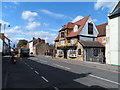
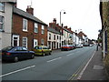
Watling Street, Towcester
Towcester is the site of the Roman town Lactodorum. The A5 follows the course of Watling Street.
Image: © Bikeboy
Taken: 21 Aug 2014
0.22 miles
8
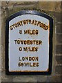
Towcester - Milepost
Historic metallic milepost on Watling Street, a former Roman road.
Image: © Colin Smith
Taken: 31 Jan 2016
0.23 miles
9
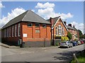
The Library, Richmond Road, Towcester
A plaque on the wall (see other photograph) indicates that this building was a Church of England School, built in 1869 and extended in 1929.
Image: © Humphrey Bolton
Taken: 1 Jun 2007
0.23 miles
10
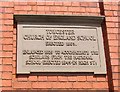
Plaque on the Library, Richmond Road, Towcester
Image: © Humphrey Bolton
Taken: 1 Jun 2007
0.23 miles